Michael Burnett
@MDMBurnettMSc Geography - Queens University Remote sensing scientist interested in urban and forested geography Musician/Hiker/Photographer/Flea Market Critic
Similar User

@dr_spoon

@MadiSophiaBrown

@IrwinLiam_UBC

@Silvilaser25

@PiotrTompalski

@EShafeian

@JosegRiofrio

@AgathaCzekajlo

@geogemgis

@yuhao_bean
@Silvilaser23 lidR workshop materials are freely available online for those who couldn't be in London. Contents are pre-rendered on the website while scripts and data can be found in the github repo! Thanks to JR for the gift of lidR! @AlexisAchim @IRSS_UBC @IrwinLiam_UBC
The materials for a 3 hour lidR tutorial workshop by Tristan Goodbody are available at buff.ly/45KGYTJ. Check them out if you are interested in processing point cloud data. #rstats #lidar #rspatial

🗺️IRSS & Silva21 Scantique Roadshow update!🗺️ @IrwinLiam_UBC & crew are in northern Ontario with the Canadian Forests Service & @ONresources at the Romeo Malette Forest flying #lidar & multispectrial imagery! Watch them get to work 👇 #remotesensing #forestryresearch #forestry
Checking out the #LiDAR #PointCloud visualization tools from #QGIS. They are so cool ! 🥳 You can adjust color ramps, select different attributes, and create nice animations as you were flying above and/or into the forest. PS: can you spot some palm 🌴 or leafless 🍂 tree?
The most neglected body part in the fitness world: Ankles. Here’re 8 exercises guaranteed to bulletproof your ankles (get rid of pain for good):

Hi everyone! For anyone that didn't know, here's a link to all my #Rstats resources in one place! I've got online courses, YouTube videos, a blog, and more! *Especially useful for grad students. Check it out here: linktr.ee/rforecology #RforEcology #ecology #gradschool #R…
🪐 Jupiter generates a mammoth magnetic field and our @ESA_Juice mission is flying right into it. But within that field lurks a clear and present danger to space missions – intense belts of radiation much more energetic and intense than Earth's. 👉 esa.int/Enabling_Suppo…
BREAKING 🚨: NASA’s James Webb telescope has captured a stunning new image of Uranus

|| NEW RESEARCH || Spatial heterogeneity of global forest aboveground carbon stocks and fluxes constrained by spaceborne lidar data and mechanistic modeling 📄 bit.ly/3MfPJ1u @NASAEarth @GEDI_Knights @UMDResearch @umdgeography @UMD_GEL

You’ve probably seen artists’ renderings of #Landsat satellites in orbit... but how about an *actual image* of a satellite in orbit? Thanks to Maxar, we now have images of Landsat 8 orbiting Earth from the WorldView-3 satellite. Enjoy! 🛰️
📢 NEW PAPER! A novel post-fire method to estimate individual tree crown scorch height & volume using simple RPAS-derived data 📰 doi.org/10.1186/s42408… ✍️Arkin, Coops, @LoriDanielsUBC, @PlowrightAndrew 💰 @FYBRinc @NSERC_CRSNG @ubcforestry #FireEcology #RPAS #Wildfire

📢NEW PUBLICATION in Forest Ecology and Management: Pre-fire measures of boreal forest structure and composition inform interpretation of post-fire spectral recovery rates #OpenAccess #forestrecovery #boreal #fire doi.org/10.1016/j.fore… A short🧵follows...

There are many ways to get across the point of distortion in the Mercator map. Here's a planisphere indicating a distance across Africa and another distance across Russia and things don't add up [source, read more: buff.ly/3HGVLme]
![Rainmaker1973's tweet image. There are many ways to get across the point of distortion in the Mercator map. Here's a planisphere indicating a distance across Africa and another distance across Russia and things don't add up
[source, read more: buff.ly/3HGVLme]](https://pbs.twimg.com/media/Fs4TR3TXgAAw_kd.jpg)
📢 NEW PAPER! Vectorial & topologically valid segmentation of forestry road networks from ALS data 📰 #OpenAccess: doi.org/10.1016/j.jag.… ✍️ Roussel, Bourdon, @LithyMorley, Coops, @AlexisAchim 🙏 Forestry Futures Trust Ontario, @NSERC_CRSNG @MFFP_Quebec @ubcforestry #Lidar

The mating dance of the male peacock spider. Credit: Michael Doe
#JobAlert reminder! Apply now for the Forester position with McLeod Lake Mackenzie Community Forest. Check out the listing on the #CIFJobBoard here: cif-ifc.org/job-board/
#JobAlert 🔔 Forester with McLeod Lake Mackenzie Community Forest 📍 Mackenzie, BC 🗓️ Open until filled Check out the listing on the #CIFJobBoard here: cif-ifc.org/job-board/

📢 NEW PAPER! Assessing forest recreational potential from social media and #RemoteSensing 📰 #OpenAccess: doi.org/10.1016/j.ecol… in @ELSenviron ✍️ @_federicolingua, Coops, Griess @ubcforestry #Lidar #ForestRecreation #BigData

I’m pleased to announce that one of my articles has been selected as Editor’s Choice Articles mdpi.com/journal/land/e…
After his successful Ph.D. defense, Dr Jeremy Arkin has been added to the wall of graduated students! Jeremy has now left the IRSS and will be missed. Check out his publications here: orcid.org/0000-0003-3373…
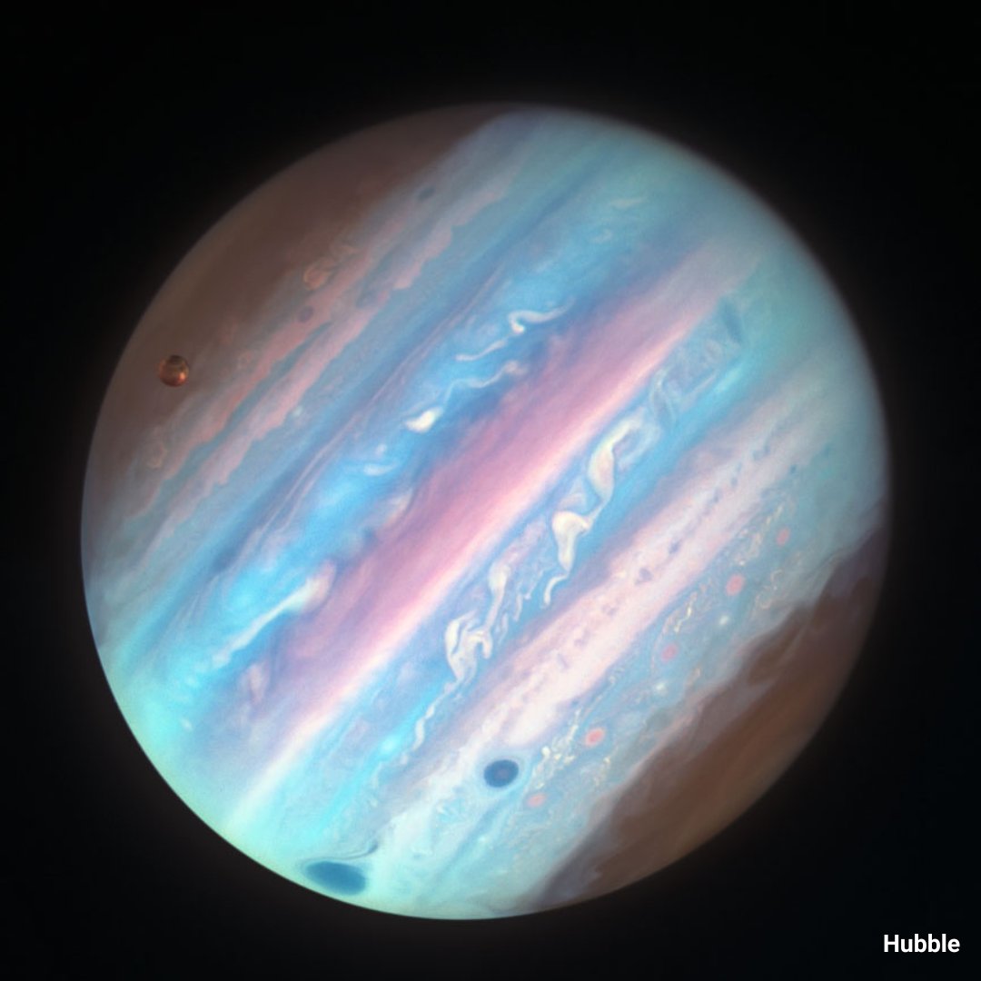
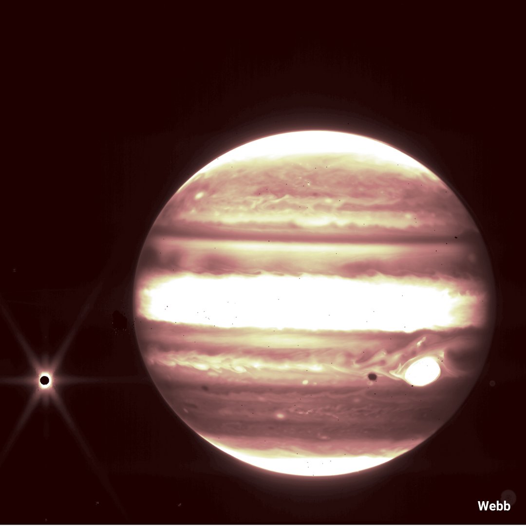
Ultraviolet ➡️ Visible ➡️ Infrared Different wavelengths mean different views! Hubble’s ultraviolet & visible images offer insight into Jupiter’s atmospheric changes and colors. @NASAWebb’s infrared view was taken to test its instruments during commissioning ⬇️

United States Trends
- 1. #AskFFT N/A
- 2. #FFNow N/A
- 3. $CUTO 12,7 B posts
- 4. Good Sunday 73,4 B posts
- 5. #sundayvibes 6.348 posts
- 6. #Alphabot 7.294 posts
- 7. #LINК 99 B posts
- 8. $BOOST 11,4 B posts
- 9. Xmas Drop 1.617 posts
- 10. Sunday Funday 4.194 posts
- 11. Bill of Rights Day N/A
- 12. DeFi 180 B posts
- 13. Deion 18,7 B posts
- 14. Vindman 13,1 B posts
- 15. Blessed Sunday 22,8 B posts
- 16. Riddick N/A
- 17. Full PPR N/A
- 18. Go Browns N/A
- 19. Gaudete Sunday 1.502 posts
- 20. Donk 12,1 B posts
Something went wrong.
Something went wrong.


