Similar User

@DrWildcatWx

@carl_schreck

@_KatieMagee_

@kevinmmcgrath

@wall_cloud

@wxjoe

@sezick

@WX_Overlord

@raoulesperas

@DangWx

@wxdoc

@JoshuaAlland

@WxTimH

@sd79wx

@jjgerth
some easterly shear may be enhancing downshear left convection in #Mawar’s southern eyewall. This could help to tug the system left of track and limit latitudinal gain…ultimately favoring a pass just south of Guam as a synoptic scale westerly track also begins to establish.

first time we've noticed a sheet of ice on the family pool going back to year 2000. chalk it up to a prolonged cold pattern heading towards the winter solstice #CAwx #Bayarea

The development of Typhoon #Hinnamnor 🌀over the last 3 days as seen from #Himawari8 🛰️#TyphoonHinnamnor
El Niña
It's funny how this La Niña persists (as forecast), yet the 𝙚𝙖𝙨𝙩𝙚𝙧𝙣 𝙚𝙦𝙪𝙖𝙩𝙤𝙧𝙞𝙖𝙡 Pacific just refuses to play nice. Note that the "NINO3.4" box (marked on the map) is the official forecasted quantity, at least by @climatesociety (iri.columbia.edu/our-expertise/…).

The biggest westerly wind burst in two years will probably spawn a typhoon near or just west of Palau and Yap. No recurve scenario...potential humdinger for the Philippines. #96W. loop from @cyclonicwx
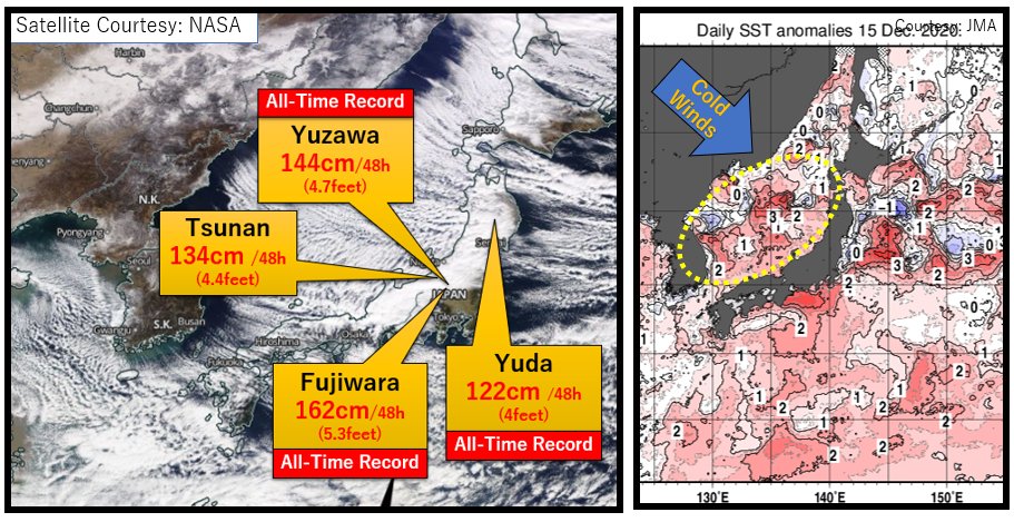
RECORD-BREAKING!! #Snow has been piling up at an unprecedented rate in #Japan. Fujiwara had 162cm (5.3feet) in 48hr. This is due to the combination of unseasonably cold Siberian air and unseasonably warm ocean temperatures. 150cm (4.9feet) is still possible into the next 48hr.
who needs satellite when you can infer intensification and position fixes from lightning data...reminds me of Yutu (2018) on approach to Tinian
Full disk WV imagery. WWB has pushed off Maritime Continent coincident w/ 4 disturbances: twins (90W by Yap/Banda Sea Low) & (92W by Kosrae/Solomon Low). W winds not particularly strong->supports maintenance of +ENSO through the summer & wishy-washy forecasts for winter 19/20.

April 15 2018: 1 year ago today the tipping bucket rain gauge at Waipā Gardens, Kauai, HI recorded 49.69" of rain in 24 hours. The data was verified by the National Climate Extremes Committee in Dec 2018. Read the full report here -> ncdc.noaa.gov/monitoring-con…


Impressive hail for the Bay Area. Overachieving West Coast storms often have big downstream impacts.
This is probably the craziest hail storm I've ever experienced, and it happened in San Jose #CaWx @SJSUmeteorology
Fresno has now reached the record number of consecutive days with highs 100 degrees or warmer! Daily max temps of 100 degrees & above have occurred since July 6th (now tied for 21 days in a row). The 100-degree streak is expected to continue for the next several days. #CAwx
My boss let me join him for a TS #Maria damage assessment at Ritidian Point. Some of the scenes we saw suggest peak winds may have surpassed the 83kt gust at Andersen AFB. Solid evidence that pockets of very strong winds, perhaps mesovorts, were bouncing along the forest canopy.


Andersen Air Force Base (elevation ~600ft) measured 83kt gust with this.. quite the tropical storm!
Good grief. Nasty formative eyewall moving into Guam now. Remarkable evolution last few hours.

9pm ChST.. #10W well offshore but elevated terrain already gusting well above 50mph. Should be an interesting night.. hopefully just wet floors and howling winds
United States Trends
- 1. #AskFFT N/A
- 2. Good Sunday 66,9 B posts
- 3. Southampton 36,1 B posts
- 4. #sundayvibes 7.629 posts
- 5. #RollWithUs N/A
- 6. #AskZB N/A
- 7. Chuck Woolery 12,2 B posts
- 8. #SOULIV 14 B posts
- 9. Robertson 9.622 posts
- 10. Michael Oliver 1.106 posts
- 11. Geraldo 4.309 posts
- 12. Robbo 1.885 posts
- 13. Bannister 1.324 posts
- 14. Konate 2.855 posts
- 15. Liverpool 101 B posts
- 16. Rachel Maddow 26 B posts
- 17. Love Connection 6.091 posts
- 18. Wheel of Fortune 5.067 posts
- 19. King of the Universe 2.180 posts
- 20. AMER 5.641 posts
Who to follow
-
 Dr. Stephen Bieda III
@DrWildcatWx -
 Carl Schreck 🛰️
@carl_schreck -
 Katie Magee
@_KatieMagee_ -
 Kevin McGrath
@kevinmmcgrath -
 Mike Johnson
@wall_cloud -
 Joe Moore
@wxjoe -
 Stephanie E. Zick, PhD ☔
@sezick -
 Jeremy Smith
@WX_Overlord -
 raoul esperas
@raoulesperas -
 Tom Dang
@DangWx -
 Wxdoc ⛈️☀️🌩️🛰️💐🌷
@wxdoc -
 Joshua Alland
@JoshuaAlland -
 Tim Humphrey
@WxTimH -
 Scott Doering - Not Here
@sd79wx -
 Jordan Gerth
@jjgerth
Something went wrong.
Something went wrong.


