Similar User

@WxChungus

@juststormchasin

@Sawyer_WX

@anemicroyaltywx

@lividwx

@ShearConvection

@Jadon_wx

@JeremyWXStorm

@Cryptic69420lol

@gavinweather

@planechasin

@Iowacloudchaser

@306StormChaser

@Wxlurker2

@SalvatoryYt
Every Intense (EF3+) Tornado Worldwide in 2024 + additional information (UPDATED 09/2024) #wxtwitter #wxx #wx #Tornado

Extreme damage from the 2020 Nashville EF3. Homes near or completely leveled and a steel beam driven into the sidewalk. Winds were estimated at 165 mph but may of been higher within the sub-vortices.


So I’ve been digging through some old Canadian tornadoes, and came across this photo, this is from the 1946 Windsor On f4, I’ve heard somewhere that it apparently cracked the foundations of homes? I’d love to hear more about this #onstorm

Which wedge was the most visibly violent in history? Below are videos of my Top 3 picks. Feel free to share links to any strong contenders!
Hello world! We're the newest program under the @westernuCSSL umbrella, alongside @westernuNTP and @westernuNHP! Our goal is to connect and enhance Canada's weather networks!
Will probably update this one more time before the end of the year, and come 01/01/2025 I will post a fully complete, fleshed out version of this with as much information and extras as I can. 🌪️❗️ #wxtwitter #wxx #wx #tornado
Big announcement coming tomorrow. Stayed tuned! 🚀
Throughout time, tornadoes have been one of the most famous phenomena to be documented on earth. Towards the middle of the 20th century, twister photography became much more common. So, In this thread, we will look at tornado pictures in every year from 1950-1975! #tornado


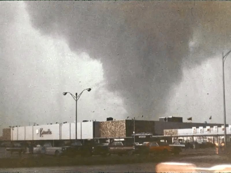

Northern most tornado funnel EVER. It Occurred on June 19, 1962 near Yellowknife, Northwest Territories, Canada. That’s only 250 miles south of the Arctic Circle, and from May-July, there virtually no “nighttime”. (cr. Jay Raymond)

📍 Aurora in Hamilton, Ontario That’s twice now this year I’ve seen this spectacle — awesome. #aurora #onstorm #wxtwitter


(1/3) Regarding today’s tornado outbreak in Florida, I’ve seen several photos with contextual damage (mainly vehicles and trees) likely nearing high-end EF3 on the EF scale. These were NOT weak tornadoes, which is atypical of TC tornado outbreaks. I have barely- ⬇️


ok but if this reply hits 5k retweets then ill try my absolute hardest to beat it without pausing
The catastrophic Hurricane #Helene has continued to RI; with NHC estimated winds of now 140MPH at CAT4 strength, along with a very low center pressure of 941(NHC) to 940MB per Recon!! Isolated gusts of much higher have been noted at *flight level* within Helene She nears land!
If that isn’t the most gorgeous, definitely-tornado-producing cell up near Lac Seul in NW Ontario… #wxtwitter #wxx #wx #tornado

Up first this morning for our General Session 2: Severe Weather and Hydrology is Dr. Mark Conder from @NWSLubbock! His presentation is entitled, "Considerations on a Revision of the EF Scale in the Wake of the 2023 June 21 Tornado in Matador, TX" #nwas24
United States Trends
- 1. #AskShadow 2.402 posts
- 2. GOTY 40,8 B posts
- 3. #AskSonic N/A
- 4. Mika 107 B posts
- 5. Balatro 22,4 B posts
- 6. #TheGameAwards 50,3 B posts
- 7. Elden Ring 31 B posts
- 8. San Marino 32,7 B posts
- 9. #ysltrial 3.914 posts
- 10. #Strobepopcat N/A
- 11. Morning Joe 87,8 B posts
- 12. Shadow of the Erdtree 11,7 B posts
- 13. Katie Hobbs 8.918 posts
- 14. Bakkt 7.909 posts
- 15. SOTE 4.054 posts
- 16. Metaphor 27,2 B posts
- 17. Ichiro 4.767 posts
- 18. Astro Bot 14,9 B posts
- 19. Game of the Year 41,2 B posts
- 20. Geoff 10,6 B posts
Who to follow
-
 Big Chungus WX
@WxChungus -
 Storm Chaser Alina Cooper
@juststormchasin -
 Sawyer Delatte
@Sawyer_WX -
 layne wx 🦋🌩️🌻
@anemicroyaltywx -
 ☃️❄️lividwx 🇺🇸🎄
@lividwx -
 Shear Convection
@ShearConvection -
 Jadonwx
@Jadon_wx -
 Jeremy Storm WX
@JeremyWXStorm -
 CrypticWX
@Cryptic69420lol -
 Gavin🇺🇸✝️
@gavinweather -
 Chibound
@planechasin -
 Iowa Cloud Chaser
@Iowacloudchaser -
 Matt
Matt
@306StormChaser -
 Wxtroll
@Wxlurker2 -
 Big Sal
@SalvatoryYt
Something went wrong.
Something went wrong.


