Melissa Griffin
@mlgriffinWX1Climatologist/Meteorologist, informal STEM outreach educator, coffee addict & @floridastate alumna. MD Native w/ FL, KY, and TN ties. Tweets/opinions are mine.
Similar User

@morganabigail

@AMSEarlyCareer

@noelcbaker

@WxComm

@jjrennie

@windbarb

@SE_AgClimate

@DrWildcatWx

@NOAABrauer

@bryanwx

@ZombieTrev5k

@tjc_12

@_KatieMagee_

@MahalikWx

@capefish
What am I willing to do to sign up @CoCoRaHS observers? Dress up as Wally the Raindrop.

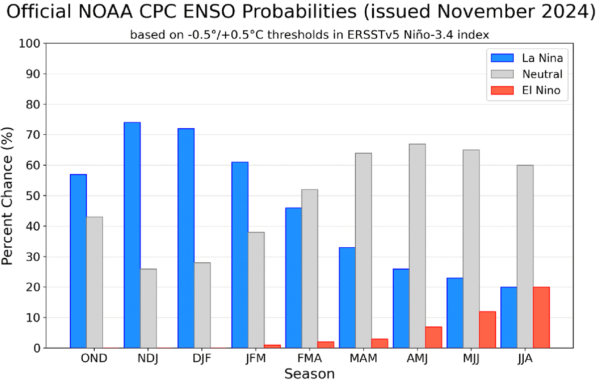
La Niña is most likely to emerge in October-December 2024 (57% chance) and is expected to persist through January-March 2025. A #LaNina Watch remains in effect. cpc.ncep.noaa.gov/products/analy…
Chilly and rather gloomy today with clouds and periods of rain. Rain will come to an end in most areas late afternoon or evening, and except near the NC/TN border, Friday will be sunny. Warming trend over the weekend. Hang in there! #ncwx #scwx #gawx

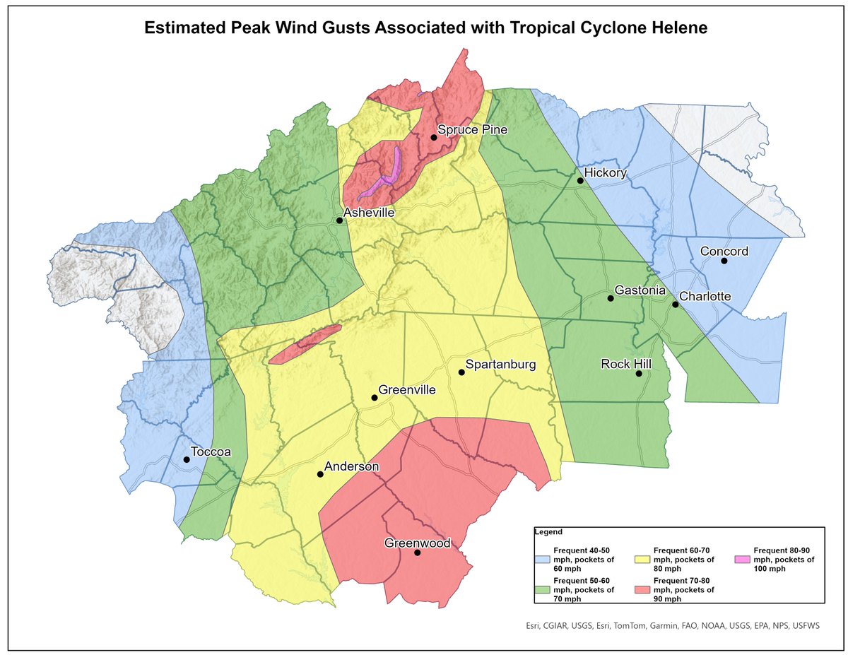
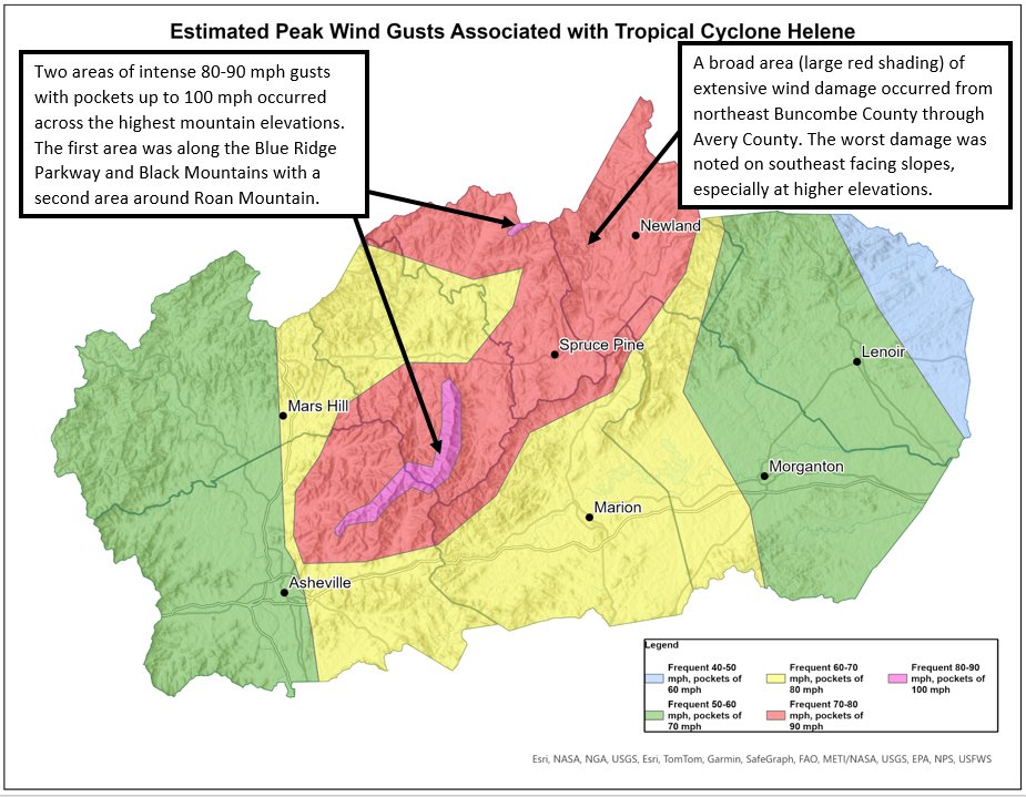
We've completed our wind damage assessment of Helene. We want to thank everyone for your patience as this was an extensive process that involved piecing together hundreds of crowd sourced damage pictures/videos, drone and aerial imagery, and high resolution satellite imagery.
#OTD in 1906, snow fell over the portions of the Midlands and Piedmont, with widespread reports of 1 to 4 inches of snow. The @NWSColumbia Little Mountain station reported 4", and the @NWSGSP stations on the campus of Clemson University and in Walhalla measured 3". #scwx


Still sunny today, but as much as 15° cooler than Tue. Then, rain will move in late tonight & continue much of Thu, bringing downright chilly temps.🥶The NC mountains might even see a little sleet mix in w/ rain as rain begins, but no impacts are expected. #ncwx #scwx #gawx

Thanks @gaclimateoffice Here is the link from #CLIMPER - sercc.oasis.unc.edu/Map.php?date=2… @FLClimateCenter @mlgriffinWX1 @VirginiaClimate @NCSCO @NOAANCEI
The North Fork of the Edisto at Orangeburg has dropped below 8 feet, prompting the ending of the Flood Warning there. However, high water and flooding downstream towards Branchville, along with the South Fork of the Edisto, will continue into mid week.

As of 10:30 AM EDT, nearly 450 @CoCoRaHS observers have submitted their 24-hour rainfall reports. Portions of the Midlands recorded more than 10"; for many observers, it was the first time they measured more than 0.25" of rain since the end of September. #scwx


Much needed rainfall headed to the area this afternoon through Thursday. Pockets of heavier rainfall, especially inland, could produce minor flooding issues. #scwx #gawx

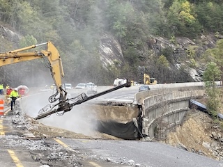
😃 More Good News! ↔️ 2-way traffic anticipated on I-40 🎉 by New Year's Day 🐌 40mph speed limit in narrow lanes 📗 Read Details: bit.ly/4eeJhSF
#Rafael 4pm EST Tue Key Messages: Rafael should be a hurricane this evening when it moves near portions of the #CaymanIslands and over western #Cuba on Wednesday. Tropical storm conditions are also expected in the #FloridaKeys Wed into Wed night More: hurricanes.gov

ON THIS DATE, 14 YEARS AGO: Widespread snow showers developed along the Tennessee border, eventually accumulating 3-8" of snow above elevations above 3500 feet by the end of the day. #ncwx

Tropical Storm #Rafael Advisory 8: Rafael Getting Better Organized as the Center Passes South Of Western Jamaica. Tropical Storm Warning Issued For the Florida Keys. hurricanes.gov
SC-CR-243 Rainfall Report…Most rainfall (0.47”) in my gauge since September 27th. @CoCoRaHS_SC @CoCoRaHS @NWSCharlestonSC @StormTeam2WCBD @WCBD

Here are preliminary climate data for October 2024 and information on temperature extremes and maximum monthly rainfall totals from @NWSGSP, @NWSColumbia, @NWSCharlestonSC @NWSWilmingtonNC, and @CoCoRaHS stations in the Palmetto State. #scwx


4pm EST Key Messages on Tropical Storm #Rafael, which is forecast to strengthen to a hurricane before reaching the #CaymanIslands area, with additional strengthening forecast before reaching western #Cuba Wednesday. TS Watches have been issued for the lower and middle FL Keys.…

A low pressure system over the southwestern Caribbean is expected to become a tropical depression during the next couple of days. Interests in the western Caribbean Sea should monitor its progress as tropical storm watches or warnings could be required later today or tonight for…

#OTD in 2014, between 1 and 5 inches of snow was reported in portions of Abbeville, Aiken, Lexington, Edgefield, and Saluda counties. This is the earliest date of known measurable snowfall on record in the Palmetto State. #scwx dnr.sc.gov/climate/sco/Pu…


An NWS Pittsburgh forecaster has been spotted waiting for rain by our rain gauge.

United States Trends
- 1. #PaulTyson 95,6 B posts
- 2. #SmackDown 17,7 B posts
- 3. Goyat 8.740 posts
- 4. Rosie Perez 1.186 posts
- 5. Cedric 5.384 posts
- 6. Bayley 4.654 posts
- 7. B-Fab 3.423 posts
- 8. Cam Thomas 1.954 posts
- 9. Max Christie 1.052 posts
- 10. Hukporti N/A
- 11. #FightNight 3.513 posts
- 12. #NetflixBoxing N/A
- 13. Karoline 36,8 B posts
- 14. Purdue 4.598 posts
- 15. Kevin Love 1.837 posts
- 16. Michin 3.120 posts
- 17. End 1Q N/A
- 18. Paige 10,3 B posts
- 19. Philon N/A
- 20. Candice 6.853 posts
Who to follow
-
 Morgan Barry
@morganabigail -
 AMS Early Career
@AMSEarlyCareer -
 Dr. Noel C. Baker
@noelcbaker -
 Gina Eosco
@WxComm -
 Jared Rennie
@jjrennie -
 Dr. Barb Mayes Boustead
@windbarb -
 Pam Knox
@SE_AgClimate -
 Dr. Stephen Bieda III
@DrWildcatWx -
 Noah Brauer
@NOAABrauer -
 Bryan Wood
@bryanwx -
 Trevor Boucher
@ZombieTrev5k -
 Tyler Castillo
@tjc_12 -
 Katie Magee
@_KatieMagee_ -
 Matt Mahalik
@MahalikWx -
 Robert Garcia
@capefish
Something went wrong.
Something went wrong.

