Kristian Ekenes
@kekenesGeography, data visualization, and cartography. Web GIS Product Engineer @esri. @BYUComms & @ASU_SGSUP alum. Still learning. Always exploring.
Similar User

@EsriDevs

@yanncabon

@lisaberry_gis

@odoenet

@NathanCShephard

@GIS_Bandit

@KiwiRichie

@inertcatnip

@EsriYPN

@CartoRedux

@spangrud

@williamscraigm

@DHansen601

@spatialsustain
Today my wife and I created our first map together to celebrate Norwegian grandfather's 100 birthday. The flag is placed at the location of his birth.


👏👏👏
Quick shoutout to @Tempegov and @TempeData 1. You have the best open data site in the state. 2. You are going above and beyond with #covid19 data by generating a time series zip code file for the whole state 3. You have a "data academy" training site. data-academy.tempe.gov
Ask any question about the @ArcGISJSAPI The questions are answered by a panel of @Esri #developers from the ArcGIS API for JavaScript team. Come on by at 11:30am (PDT); we'd love to hear from you! @EsriDevSummit
In "The Road Ahead: ArcGIS API for JavaScript" session, product managers and #development leads discuss the roadmap and development strategy for the ArcGIS API for JavaScript. We get started at 7:00AM (PDT)! #DevSummit #plenary
I love the geospatial community. At yesterday's #esri #devsummit plenary I wore this unlabeled street map t-shirt. Later in the day I got an anonymous note from someone correctly identifying the city. Can you? #geodev

I'm excited to participate in Esri #DevSummit this year! If you have any questions about JavaScript (@ArcGISJSAPI), data viz, rendering, smart mapping, or anything #esrijs related. Don't hesitate to reach out.
You can create some complex symbols with CIM, useful, powerful stuff. Or just get silly like me. odoe.net/blog/cimbology #CIMbology #esrijs #geodev #CIMmademedoit

I got sessions on sessions for #DevSummit using #esrijs esri.com/en-us/about/ev… and check out all the #webdev sessions esri.com/en-us/about/ev… #justkeepscrolling #geodev

This aged well. 😆
Gonzaga vs. Oral Roberts in the national championship game. Calling it now. 😂
Gonzaga vs. Oral Roberts in the national championship game. Calling it now. 😂
WDYD when Eastern Washington and Gonzaga are both in Spokane County? Just give EWU the next county to the west? 🤔🤔🤔
#MarchMadness Map 🗺 Each county is assigned to the closest team in the bracket! (via @jloose128, @redditCBB)
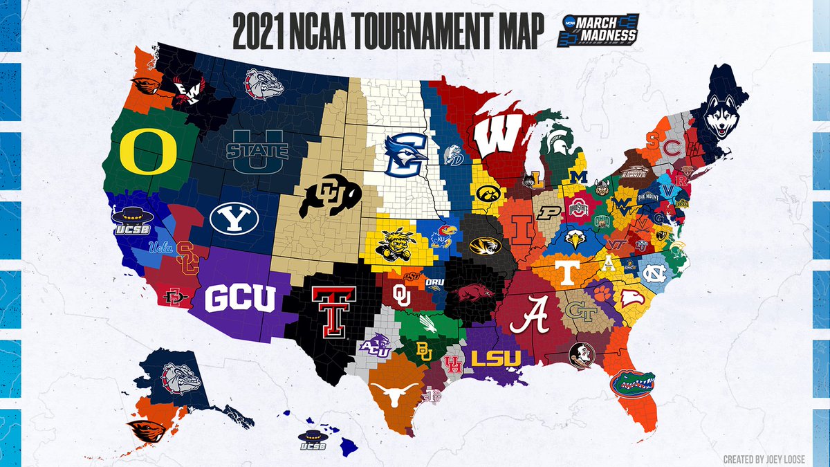
Took this survey several years ago. This was my exact map. Born raised in Spokane. Lived near Salt Lake for several years. Married in Boise.
#MarchMadness Map 🗺 Each county is assigned to the closest team in the bracket! (via @jloose128, @redditCBB)

United States Trends
- 1. Thanksgiving 555 B posts
- 2. #CONVICT 6.280 posts
- 3. #ConorMcGregor 6.606 posts
- 4. Mbappe 339 B posts
- 5. Custom 83,1 B posts
- 6. Madrid 464 B posts
- 7. #billboardisoverparty 47,1 B posts
- 8. #Overwatch2Sweepstakes 4.868 posts
- 9. Gonzaga 5.603 posts
- 10. Mendy 19,3 B posts
- 11. HAZBINTOOZ 5.757 posts
- 12. Notorious 11,8 B posts
- 13. #YNWA 6.958 posts
- 14. Conor Bradley 25,4 B posts
- 15. Ancelotti 52,7 B posts
- 16. Zags 1.157 posts
- 17. Kelleher 36,6 B posts
- 18. Courtois 18,5 B posts
- 19. Endrick 23,6 B posts
- 20. Mountaineers 1.907 posts
Who to follow
-
 Esri Developers
@EsriDevs -
 Yann Cabon
@yanncabon -
 Lisa Berry
@lisaberry_gis -
 Rene (Hecho En East Los) Rubalcava
@odoenet -
 Nathan Shephard
@NathanCShephard -
 Derek Law
@GIS_Bandit -
 Richie Carmichael
@KiwiRichie -
 Jeremy Wright
@inertcatnip -
 Esri Young Professionals Network
@EsriYPN -
 Tommy 🗺️
@CartoRedux -
 Damian
@spangrud -
 Craig Williams
@williamscraigm -
 David Hansen
@DHansen601 -
 Matt Ball
@spatialsustain
Something went wrong.
Something went wrong.


