Anthony V
@anthonyvwxRookie storm spotter/chaser. Not affiliated with NWS/SPC/etc. Backgound photos from http://t.co/Jzx6xGSr6G. SpotterNetwork: 31254
Similar User

@blazedzombie12

@dopplerbobtwist

@JeffSpencerWX

@SerietahMage

@highplainstours

@Chad_Berryhill

@Fillereste

@54stormywill54

@StormTechChaser
Of course it'll be stormy today—the Dyess radar appears to be down.
4pm: Storms developing near and behind dry line. A rapid increase in storms xpctd by 6 pm west of I-35. #txwx #dfwwx

2:34pm CDT #SPC #PDS_Watch WW 109 TORNADO OK TX 261930Z - 270500Z, go.usa.gov/cuWzx

#NWSUPDATE Severe Weather Potential- Tuesday wx5fwd.org/NWSUpdate #ntxwx #dfwwx #fwdspotter

Showers in the morning, sunny in the evening, storms at supper time; with Tornado Alley, you can have supercells anytime.
Here is an updated timeline of the expected squall line across north and central TX overnight. #txwx #ctxwx #dfwwx https://t.co/cB3rqttIZx

6PM to 8AM model loop shows scat'd storms ~10pm, then squall line moving thru N TX 2am-7am. #dfwwx #WeatherAware https://t.co/sJGQn1LLX2
Campbell Field- #Corsicana Municipal Airport has recorded 13.25 inches of rain today! #dfwwx
8 Jaw-Dropping Images from the #Houston #Flood Nightmare @weatherchannel fw.to/yViDz4V
Moderate risk doesn't always mean tornado. Today's upgrade was for hail and wind. Words come from probabilities http://t.co/g9lsThSnra

Via @NWSFortWorth, in the last hour, Lewisville has received 1.73" of rain. #dfwwx
3:23 AM - DFW airport just picked up 0.71" in the past 10 minutes. #dfwwx Total since midnight has been 2.31" and still falling #tadd #txwx
Linkin Park on stage tonight @Rocklahoma was the first band to be StormReady... nws.noaa.gov/com/weatherrea… Tonight is a night to be StormReady.
@amosmagliocco: Nervous about it down here in Lewisville. So much for that Marginal Risk, huh?
This situation is similar to the Rio Vista storm. Slow moving, intense circulation. Respect this dangerous storm in Jack & Wise counties.
Severe storm threat is expected to increase late Saturday - highest risk should stay N. of DFW though. RS #dfwwx http://t.co/J87Vh4pizr

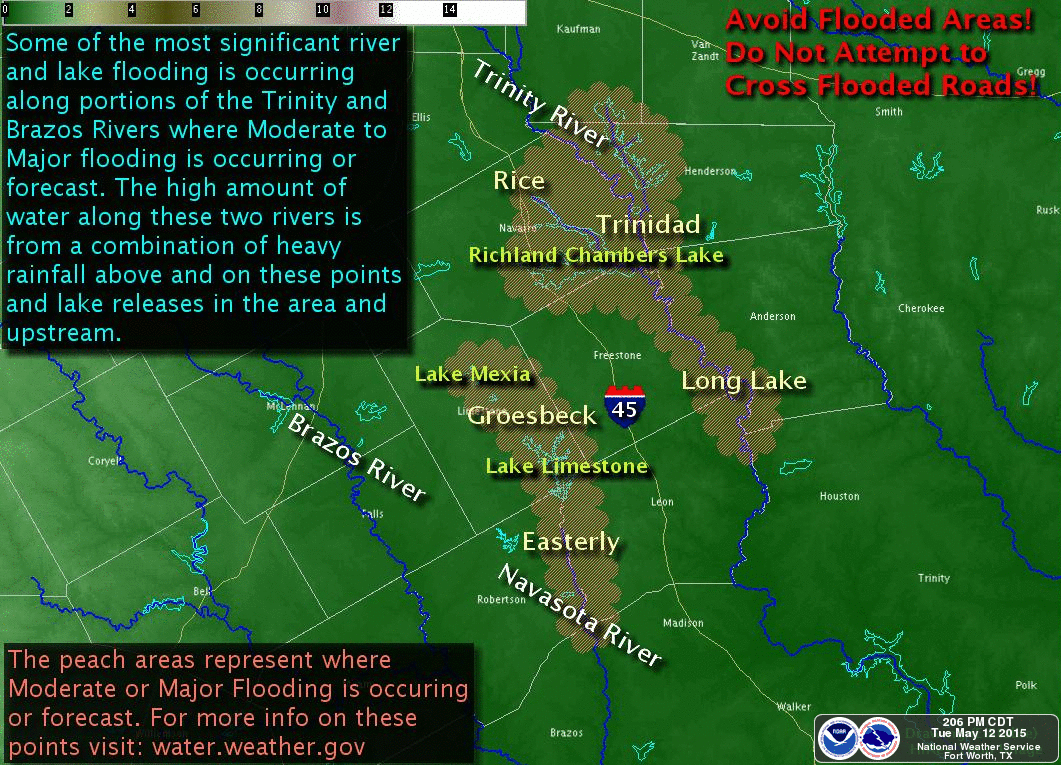
COR: Mod-Major River Flooding on parts of the Trinity & Navasota. Don't drive into flooded areas! #ctxwx #txwx http://t.co/tsZxm01Nq9
Fifth straight day of long-duration severe wx operations at WFO Fort Worth. Damn proud to work with these folks! http://t.co/NyouhAhCsb

316PM Highway 121 near Gunter of a tornado. #txwx #dfwwx twitter.com/rjhalltech/sta…
United States Trends
- 1. ICBM 134 B posts
- 2. #KashOnly 17,8 B posts
- 3. The ICC 42,4 B posts
- 4. Good Thursday 27,1 B posts
- 5. #ThursdayVibes 3.796 posts
- 6. International Criminal Court 45,7 B posts
- 7. #Thursdaytechnology N/A
- 8. Netanyahu and Gallant 69,1 B posts
- 9. Happy Friday Eve N/A
- 10. Bezos 28,5 B posts
- 11. Dnipro 56,2 B posts
- 12. #ThursdayMotivation 5.220 posts
- 13. Adani 807 B posts
- 14. #21Nov 3.177 posts
- 15. Reece James 8.918 posts
- 16. Diddy 4.728 posts
- 17. Katie Couric N/A
- 18. Nikki 54,2 B posts
- 19. MIRV 6.323 posts
- 20. Thirsty Thursday 2.257 posts
Something went wrong.
Something went wrong.


