hfu
@_hfu_Keep web maps open for a better world. Test new technologies for future geospatial operations. / Lead, UN Smart Maps Group, UN Open GIS Initiative.
Similar User

@ujigis

@MIERUNE_inc

@tosseto

@osgeojapan

@niyalist

@geoloniamap

@GISNEXT

@mapconcierge

@wata909

@shi__works

@jg2tkh

@SOCO1204

@nyampire

@kanahiro_iguchi

@waigania13
Finally here! Explore Korea's visionary 6 new towns in stunning @opengeospatial 3D Tiles? Visit dtinfo.lh.or.kr and choose one to begin virtual tour. All data has been converted into 3D Tiles using mago3DTiler(github.com/Gaia3D/mago-3d…), an open-source 3D Tiles converter.


We released the maplibre-cog-protocol to display @cogeotiff (RGB images, DEMs for terrain or hillshading, rasters colored with ColorBrewer) in @maplibre npmjs.com/package/@geoma… github.com/geomatico/mapl… Feedback is welcome!
🗺️State of the Map 2024 Diego Gonzalez presented how #UNMaps has been both using and contributing to #OpenStreetMap #opendata and #community through mapping for #peacekeeping and capacity building activities. Join us! 🙌

built pmtiles-styling.pages.dev to make it easier to style protomaps basemaps this is me using it (alongside chatgpt) to create a fall-themed basemap
Global #Terrain22 is now at Full Operational Capacity ;-) optgeo.github.io/terrain22/#9.2…
🌟 Congrats to our Mapper of the Month: Taichi Furuhashi - @mapconcierge, professor at Aoyama Gakuin University in Japan 🇯🇵 🎓Driven by a passion for empowering communities, Taichi enrolled his students in our #OSM validation course. Read the interview➡️tinyurl.com/MOTM0824

📢 On the occasion of the Paris 2024 Olympic Games, we are offering our volunteers a truly exceptional competition: the UN Mappers #MappingChampionship! 🗺️ Test your mapping skills, map with us, and climb to the podium! 🏅 Ready, set, map!👉tinyurl.com/MapChamp

Country-Wide Terrain Tiles on Demand. From Cloud Optimized GeoTIFFs (COG) to quantized-mesh terrain format research.geodan.nl/country-wide-t…

国土地理院の最適化ベクトルタイルから送電線を抽出してグローエフェクトを適用してみるなど。こことか気になるかも🗼 shiwaku.github.io/gsi-bvmap-powe… #FOSS4G #MapLibre


#Terrain22 is now available in South and East Asia. optgeo.github.io/terrain22/#9.2… #PMTiles through @source_coop Added #maplibre-contour.
#栃木県 w/ #林野庁森林整備部 #森林資源データ #樹種ポリゴン & 0.5m #デジタル標高データ with Maplibre GL JS and Observable observablehq.com/d/127ac70c12f4…
Added global contour line support to #Terrain22 using @maplibre-contour (thx to @smellman). observablehq.com/d/15509f3ef76b… DYK how to use WEBP terrain tiles in (@source_coop-hosted) @protomaps #PMTiles with maplibre-contour? This version uses terrarium instead.
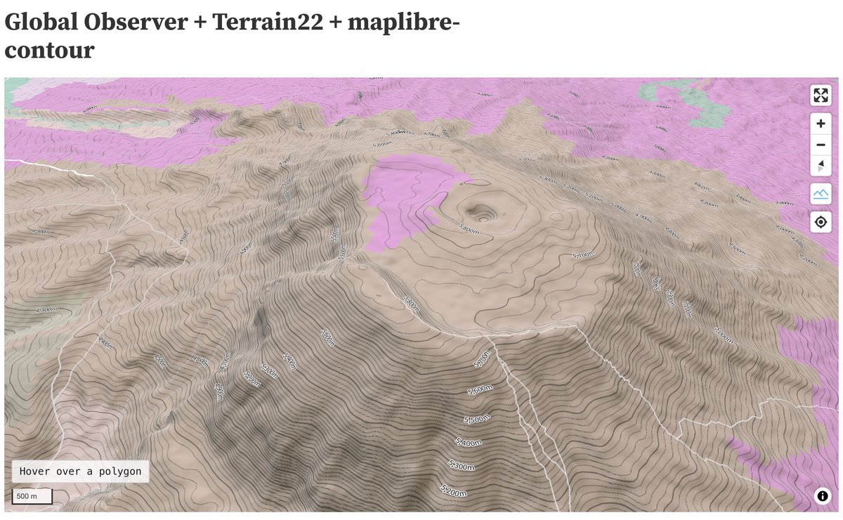
Global landform classification #Terrain22 #PMTiles now covers Cairo, Egypt. optgeo.github.io/terrain22/#9.9…

埼玉県の国道299号正丸トンネルの3次元点群データから3D Tilesを生成して、MapLibre GL JS + deck.glで表示してみました。 3D地形の内部にトンネルを配置できた🙂 MapboxOverlayを使ったオーバーレイです📝 #MapLibre #deckgl #埼玉県 #3次元点群データ #点群データ
United States Trends
- 1. $CUTO 7.779 posts
- 2. Ken Paxton 2.824 posts
- 3. ICBM 202 B posts
- 4. $SOLCAT 3.620 posts
- 5. #JusticeforDogs 1.329 posts
- 6. Jussie Smollett 13,5 B posts
- 7. Volvo 9.147 posts
- 8. The ICC 302 B posts
- 9. Senator Gaetz 29,9 B posts
- 10. Denver 36,1 B posts
- 11. Netanyahu 619 B posts
- 12. Illinois Supreme Court 12,5 B posts
- 13. Julian Lewis 7.566 posts
- 14. Rubio's Senate 3.057 posts
- 15. Dearborn 7.860 posts
- 16. Andrew Bailey N/A
- 17. Flat 52,1 B posts
- 18. Coach Prime 4.890 posts
- 19. #pilotstwtselfieday N/A
- 20. Katie Couric 2.988 posts
Who to follow
-
 あおきGIS・オープンデータ研究所@うじじす
@ujigis -
 MIERUNE Inc.
@MIERUNE_inc -
 Toshikazu SETO
@tosseto -
 一般社団法人OSGeo日本支部(OSGeo.JP)
@osgeojapan -
 Masaki Ito
@niyalist -
 geolonia
@geoloniamap -
 GIS NEXT
@GISNEXT -
 Taichi Furuhashi 🇺🇦
@mapconcierge -
wata909@鳥取
@wata909 -
 shi-works
@shi__works -
 Toru Mori
@jg2tkh -
 SOCO / 業務改善と位置情報
@SOCO1204 -
 nyampire - Satoshi
@nyampire -
 Kanahiro Iguchi
@kanahiro_iguchi -
 Kosuke ASAHI
@waigania13
Something went wrong.
Something went wrong.

