Scott Sabol, Meteorologist CBM/CCM
@ScottSabolFOX8WJW Lead/AM Meteorologist. AMS-Certified Broadcast/Consulting/Digital Met., Sabol Bros. Podcast, Behavioral Meteorology, SLU-College baseball, husband,dad
Similar User

@fox8news

@wkyc

@wkycweather

@AndreBernier

@cleveland19news

@NWSCLE

@holliesmiles

@WayneDawsonFox8

@toddmeany

@Kristi_Capel

@ajcolby

@TowerLightsCLE

@ODOT_Cleveland

@edgallekfox8

@WintzWeather
Here is the seasonal snow through November 20th for every winter since 1950 here in Northern Ohio. Does not take into account lake effect. I highlighted the years with zero snow
Why is the positive phase of the Tropical-Northern Hemisphere pattern (+TNH) becoming more frequent ? Imho, the heightened frequency of +TNH is being driven largely by the North Indian & Western Pacific Oceans warming faster than the adjacent Eastern Pacific. This changes the…


Building on some of my previous tweets about the Tropical Northern Hemisphere (TNH) pattern & this coming winter: The thing that’s become hard to ignore is the fact there’s a noticeable long-term trend towards more frequent +TNH (Hudson Bay “polar” vortex pattern) in winter. In…


My post from November 7th Highlighting increasing confidence that temps will trend below normal around Nov 21-22 and beyond
When will the milder East cooler cooler West alignment across the US change? Huge Ridge over Northern Europe breaks down and head back into the Northern Atlantic over the next 2 wks. SE ridge seems to flatten=colder east around 11/22-25. Will the Pacific pattern change to match?
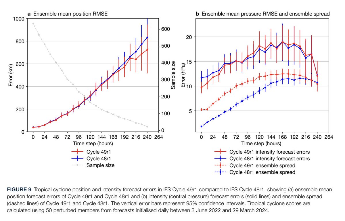
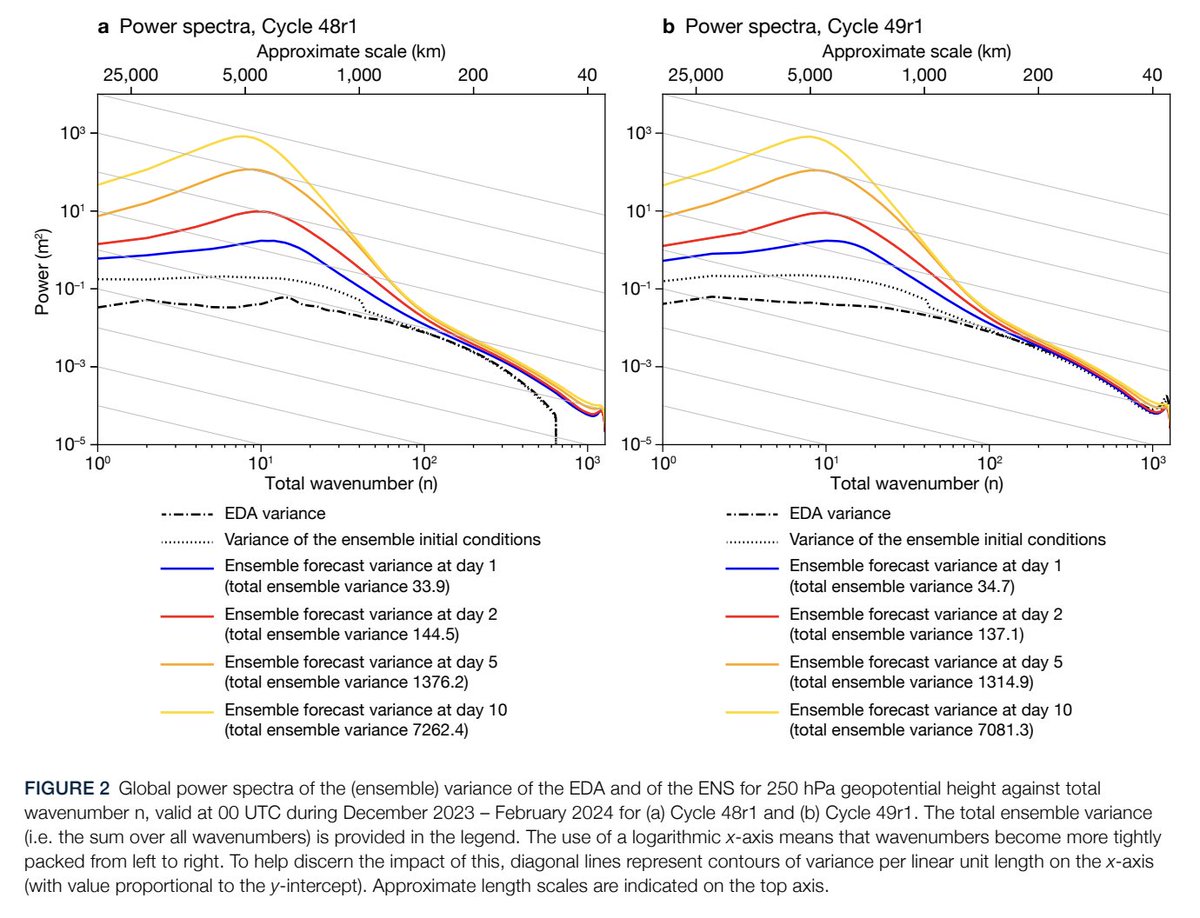
The #ECMWF is getting a significant upgrade today (IFS Cycle 49r1) beginning with the 06 UTC run. Changes include: 1) Improved Ensemble Data Assimilation (EDA) run at higher horizontal resolution. 2) Ensemble switch from SPPT to SPT. Details: ecmwf.int/sites/default/…

2015-16 Warriors: 24-0 1993-94 Rockets: 15-0 1948-49. Wash Capitols. 15-0 2002-03 Mavericks: 14-0 1957-58 Celtics: 14-0 1996-97 Bulls: 12-0 1982-83 SuperSonics: 12-0 1997-98 Lakers: 11-0 1997-98 Hawks: 11-0 1990-91 Trail Blazers: 11-0 1964-65 Celtics 11-0 2024-25 Cavaliers 11-0
Additional weather information regarding next month and the drivers
5/5 This next phase could therefore lead to a new transfer of momentum from the troposphere to the stratosphere with atmospheric blocks.


20 pt rise in the southern oscillation index last few days. Given relatively weak La Nina shows this correlation btw Nov 26-December 4: Trough from Great lakes east/Central US ridge. If this holds an interesting storm scenario could develop eastern us Tgivung. Something to watch.

Using meteorological records, @NWSMarquette, @NWSCLE, & GLERL scientists modeled the weather conditions & wave heights that caused the tragic #EdmundFitzgerald wreck. At the height of the storm, modeled waves peaked around 25.5 ft (7.8 m). glerl.noaa.gov/pubs/fulltext/… #LakeSuperior
Winter weather outlook video is posted in my pinned profile. Check it out!
Fantastic six-part post on a major driver of winter. The difference is between a warm and cooler stratosphere and the impact that has on surface weather 🌡️
1/6 Dynamical extreme situations of the sPV during northern winter are known to have an impact on tropospheric dynamics [Baldwin and Dunkerton]. These stratospheric events occur in the form of either a weakening of the PV, i.e., SSW, or a strengthening of the polar vortex.


When will the milder East cooler cooler West alignment across the US change? Huge Ridge over Northern Europe breaks down and head back into the Northern Atlantic over the next 2 wks. SE ridge seems to flatten=colder east around 11/22-25. Will the Pacific pattern change to match?
Number of days with average temperatures above normal from September 1st through November 7th over the last 40 years in NE Ohio @NWSCLE @fox8news
Another variable in our winter Outlook
The monthly PDO index dropped to -2.4 in October, the lowest of any month since 1955. This negative PDO extreme is mostly associated with NW Pacific warmth: SST anomalies as high as +4°C and +4 standard deviations. Remarkable subsurface warmth as well (CPC figure).


Pattern across the US a direct result of an amplified jet stream coming off Eastern Asia due to Himalayan Mtn interaction + strong MJO thru Indonesia + strong Polar Vortex. Huge block developed in northern Europe & Northern Pac. Lows develop west,fall apart as they hit SE US high
United States Trends
- 1. Clemson 9.499 posts
- 2. Travis Hunter 20,4 B posts
- 3. Heisman 9.293 posts
- 4. Colorado 75,8 B posts
- 5. Zepeda 3.611 posts
- 6. Dabo 1.629 posts
- 7. Ty Simpson N/A
- 8. Arkansas 27,8 B posts
- 9. Ceyair Wright N/A
- 10. Utah 35,7 B posts
- 11. DJ Lagway N/A
- 12. #iubb N/A
- 13. Quinn 15,1 B posts
- 14. Tyler Warren N/A
- 15. Narduzzi N/A
- 16. Cam Coleman 1.469 posts
- 17. #SkoBuffs 5.367 posts
- 18. Pentagon 111 B posts
- 19. Sean McDonough N/A
- 20. Isaac Wilson 1.030 posts
Who to follow
-
 fox8news
@fox8news -
 WKYC 3News
@wkyc -
 WKYC 3weather
@wkycweather -
 Andre Bernier
@AndreBernier -
 Cleveland 19 News
@cleveland19news -
 NWS Cleveland
@NWSCLE -
 Hollie Strano
@holliesmiles -
 Wayne Dawson
@WayneDawsonFox8 -
 Todd Meany
@toddmeany -
 KristiCapelTV
@Kristi_Capel -
 AJ Colby
@ajcolby -
 Terminal Tower CLE
@TowerLightsCLE -
 ODOT Cleveland
@ODOT_Cleveland -
 Ed Gallek
@edgallekfox8 -
 Matt Wintz
@WintzWeather
Something went wrong.
Something went wrong.


