Spatial Ventures
@SVL_KenyaSVL provides open source Geospatial solutions and services to private enterprises and to Government entities; enabling the transition to open source GIS
Similar User

@EsriEA

@Moses__Mwania

@OSMKenya

@Ramani_Group

@AfricaGeoPortal

@OakarServices

@kenmubea

@LocateIT_KE

@Anastasia__mw

@GMS_Mapping

@KUGIS_Club

@james_magige

@EngSteveMwai

@UjuziKilimo

@Sammie_Munyua
Have u ever wondered why sorgum does well in siaya county?Contact Spatial Ventures for more location based data insights @Baringo_county @GovernorKiptis @siayagovt @KenyaGovernors @siayagov

thinking about my ex who always said please and thank you when he asked chatGPT a question and when I asked him why he said “when it becomes sentient and powerful it will remember who was polite”
BREAKING NEWS Surveyors and other professionals in Kenya won't skip reading this thread in case you're also experiencing the same with your professional organization. @Kenyans @Tuko_co_ke @ntvkenya @citizentvkenya Thread👇
"The Global South is not a treasure chest for plunder. We deserve systems that are fit-for-purpose, not extractive & exploitative." Amos Wemanya of @PowerShftAfrica talks to @DubaiEye1038FM
Your open source contribution doesn't need to be perfect It needs to be good enough to add value!
Machine Learning is becoming the default way to build technology, mostly thanks to open-source & open-science but I don’t think we’re anywhere close to singularity/AGI/terminator/AI God (if it even exists) (1/5)
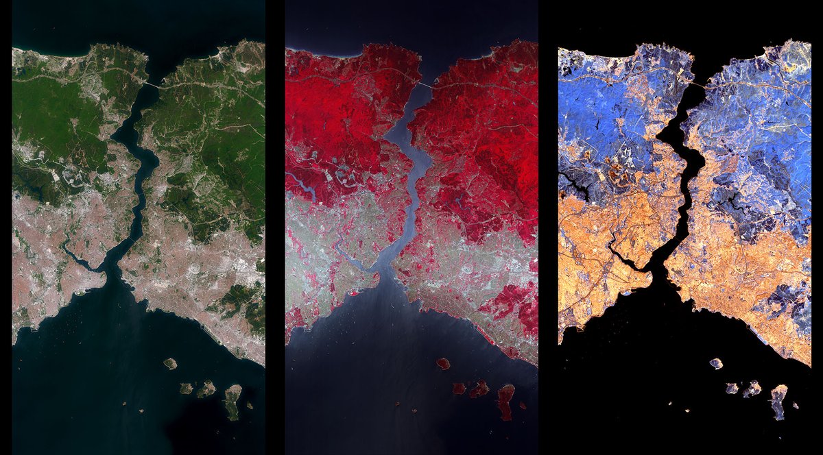
#EnMAP has sent the first images - and already the first data from the 🇩🇪 environmental satellite show the power of the hyperspectral instrument! 💪 The first images show Istanbul on the Bosporus in Turkey with Europe to the west and Asia to the east.
I'm looking for a couple of keen EO/geospatial people interested in some work at an operational space agency. Training can be provided. For now a short term opportunity, with scope for extension. Ideally need to be based in Germany (at least Europe). DM me for more info. #eojobs
How @openstreetmap @OSM_Tech uses @fastly's CDN to push near-instant tile updates worldwide, by @hannahleetweets Thank you Fastly for your support! fastly.com/blog/how-opens…
If taking calculated risks was a video.
Yesterday, our team held a successful training workshop with officials from Nakuru, one of the largest metropolitan centers in #Kenya, that recently attained city status. The Satellite Imagery for Social Good project seeks to provide #geospatial datasets of the new city. #OSM

Ridiculous but true fact: Zoom, the teleconferencing app, has done more to reduce emissions than electric vehicles.
Physics always very cool
NASA awards researchers from Cornell University a USD 1 million grant to develop the first high-resolution carbon monitoring system that combines “bottom-up” ecological modelling with “top-down” satellite data for East Africa. africanews.space/nasa-awards-us…
In 1995, only two years after the birth of the worldwide web, @BillGates tried to explain ‘The Internet’ to Letterman. Today, tech pioneers face the same redicule as they describe AI and blockchain
An #eruption of #Nyiragongo #volcano (#DRC) began in the evening of May 22. #Meteosat satellite data (from @CIRA_CSU) show a strong thermal anomaly appearing at 17:15 UTC, and a small #volcanic plume amidst widespread regional convection. Follow @CharlesBalagizi for updates.
“When we started our first company, we rented a small office and slept on the couch. We showered at the YMCA. We had one computer — so the website was up during the day and I was coding at night.” ~Elon Musk (2014)
Nimefanya hizi zote lakini wapi 😭
The cost of success; 1. Late nights 2. Early mornings 3. Very few friends 4. Being misunderstood 5. Feeling overwhelmed 6. Questioning your sanity 7. Being your own cheerleader But guess what? It will be worth it. #AskKirubi
A new R package on CRAN: Treetop: A Shiny-based Application for Extracting Forest Information from LiDAR data. github.com/carlos-alberto…

#AfDataCube shows coastal change in #Mombasa, #Kenya 2013 - 2018. RED - land to water, GREEN - water to land. @OpenDataCube #EarthObservation for #SDGs @Data4SDGs Better data for decision making #LeaveNoOneBehind on #GlobalGoals @UNEP @CEOSdotORG @spaceinafrica1 @SpaceASW
United States Trends
- 1. $CUTO 8.039 posts
- 2. Jeremiah Smith N/A
- 3. #collegegameday 3.889 posts
- 4. DeFi 105 B posts
- 5. $CATEX N/A
- 6. Broden N/A
- 7. #Caturday 8.488 posts
- 8. Denzel Burke N/A
- 9. Northwestern 3.874 posts
- 10. $XDC 1.573 posts
- 11. Renji 4.872 posts
- 12. Henry Silver N/A
- 13. #MSIxSTALKER2 6.682 posts
- 14. Jayce 92,9 B posts
- 15. Bessent 3.204 posts
- 16. Wrigley Field 1.147 posts
- 17. #Arcane 321 B posts
- 18. Pence 83,2 B posts
- 19. Pat McAfee N/A
- 20. Lutnick 1.752 posts
Who to follow
-
 Esri Eastern Africa
@EsriEA -
 Moses Mwania
@Moses__Mwania -
 OpenStreetMapKE
@OSMKenya -
 Ramani Geosystems
@Ramani_Group -
 Africa GeoPortal
@AfricaGeoPortal -
 Oakar Services
@OakarServices -
 Ken Mubea
@kenmubea -
 LocateIT_KE
@LocateIT_KE -
 Anastasia
@Anastasia__mw -
 Geoscience Mapping Solutions
@GMS_Mapping -
 Kenyatta University GIS Club
@KUGIS_Club -
 James Magige
@james_magige -
 Steve Mwai
@EngSteveMwai -
 UjuziKilimo
@UjuziKilimo -
 Samuel Kimani
@Sammie_Munyua
Something went wrong.
Something went wrong.


