NWSHonolulu
@NWSHonoluluProviding weather, hydrologic, and climate forecasts and warnings for the protection of life and property and the enhancement of the U.S. economy.
Similar User

@Oahu_DEM

@HonoluluGov

@HawaiiNewsNow

@DOTHawaii

@Hawaii_EMA

@NWSLMRFC

@pacificbiznews

@NHC_Pacific

@hawaiibusiness

@BWSHonolulu

@NWSLubbock

@KITV4

@CivilDefenseHI

@NWSSouthern

@StarAdvertiser
Trade winds will remain windy through the weekend. Showers will pass over windward and mauka areas, while also lingering over some leeward areas. Drier air should move in by Friday, followed by increased showers Saturday.
A cold front just north of Kauai will move SE and stall near Maui County and dissipate late today and tonight. Trade winds overrunning the front have arrived to the islands and push upstream clouds and showers across the islands over the next couple of days. #hiwx

Flash Flood Warning continues for Hilo HI, Kailua HI and Waimea HI until 4:45 AM HST

Flash Flood Warning continues for Hilo HI, Kailua HI and Waimea HI until 1:45 AM HST

Flash Flood Warning continues for Hilo HI, Kailua HI and Waimea HI until 1:45 AM HST

Flash Flood Warning continues for Hilo HI, Kailua HI and Waimea HI until 10:45 PM HST

Flash Flood Warning including Hilo HI, Kailua HI and Waimea HI until 10:45 PM HST

Flash Flood Warning continues for Hilo HI, Waimea HI and Volcano HI until 7:30 PM HST

Flash Flood Warning including Hilo HI, Waimea HI and Volcano HI until 7:30 PM HST

Tropical moisture will bring the potential for locally heavy rain and a few thunderstorms through Tuesday. A cold front will approach the islands and progress part-way through the state on Wednesday into Thursday morning.

Tmrw marks the 20th anniversary of the Manoa Valley flood that heavily impacted the University of Hawaii campus where the National Weather Service is located. For more info on the event, please check out our write up of the event here. weather.gov/hfo/ManoaFlood… PC: Bob Ballard

Flash Flood Warning continues for Pearl City HI, Kailua HI and Waipahu HI until 1:15 PM HST

Flash Flood Warning continues for Hana HI and Wailua HI until 9:45 AM HST

Flash Flood Warning including Hana HI and Wailua HI until 9:45 AM HST

Locally heavy rainfall is possible this weekend over Maui and Big Island, as well as leeward portions of the western half of the state. Light to moderate trade winds will also continue through the weekend, until strengthening beginning of next week.
In light of the recent Wet Season Outlook, here are some wet season preparedness reminders! When flooded, turn around! Don't drown! #hiwx
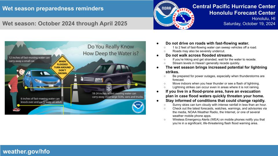
The 2024-2025 Wet Season Outlook was released October 17, 2024. Probabilities favor a weak La Nina and climate model consensus favors large scale above average rainfall from December 2024 through April 2025. #hiwx

Members of the USCGC Kimball presented a letter of recognition during a tour today. "The collaboration between NOAA and the USCG has always been a cornerstone of effective disaster response, and the recent hurricanes underscores the strength and importance of our partnership. "

Enhanced showers are expected today as a weak low level disturbance moves west across the state. Most showers will be over windward and mauka areas, with some lingering over leeward areas. Expect drier conditions tomorrow morning through mid week.
A low aloft will destabilize the island atmosphere this weekend, bringing the potential for some locally heavy showers and a chance for thunderstorms. Expect stronger trade winds to return next week.

United States Trends
- 1. $MAYO 10 B posts
- 2. Tyson 392 B posts
- 3. Pence 44,6 B posts
- 4. Laken Riley 40,1 B posts
- 5. Dora 22,5 B posts
- 6. Ticketmaster 16,6 B posts
- 7. Kash 72,4 B posts
- 8. Mike Rogers 8.766 posts
- 9. #LetsBONK 6.205 posts
- 10. Cenk 11 B posts
- 11. Pirates 19 B posts
- 12. Debbie 16,7 B posts
- 13. #FursuitFriday 15,6 B posts
- 14. Iron Mike 16,3 B posts
- 15. Mr. Mayonnaise 1.381 posts
- 16. The UK 439 B posts
- 17. Gabrielle Union N/A
- 18. Fauci 175 B posts
- 19. Scholars 10,8 B posts
- 20. Oscars 14 B posts
Who to follow
-
 Oahu Emergency Mgmt.
@Oahu_DEM -
 City of Honolulu
@HonoluluGov -
 Hawaii News Now
@HawaiiNewsNow -
 Hawaii DOT
@DOTHawaii -
 Hawaii EMA
@Hawaii_EMA -
 NWS LMRFC
@NWSLMRFC -
 Pacific Business News
@pacificbiznews -
 NHC Eastern Pacific
@NHC_Pacific -
 Hawaii Business Magazine
@hawaiibusiness -
 Honolulu Board of Water Supply
@BWSHonolulu -
 NWS Lubbock
@NWSLubbock -
 Island News
@KITV4 -
 COH Civil Defense
@CivilDefenseHI -
 NWS Southern Region
@NWSSouthern -
 Star-Advertiser
@StarAdvertiser
Something went wrong.
Something went wrong.


