UNT Emergency Management
@MeanGreenReadyBe #MeanGreenReady! Our mission is to create a culture of readiness by ensuring the #UNT community is actively involved in emergency preparedness 💚💪🦅
Similar User

@UNTsocial

@UNTEagleAlert

@UNTActivities

@UNTPrez

@UNTnews

@UNTPolice

@UNTFacilities

@UNT_DSA

@UNTclass

@BNatUNT

@UNTdining

@UNTUnion

@UNTtransit

@UNTAdvancement

@UNT_UPC
After yesterday's record-breaking heat, today will be much cooler with highs in the 50s. A Freeze Watch is in effect for parts of North TX tonight. This will be the first widespread freeze of the season. Happy Thanksgiving North and Central Texas! #dfwwx #ctxwx


It's Barbie's world and we're just living in it! Thank you to all who have donated to Toys for Tickets and received twice the receipt price to go toward paying down your citations. All toys benefit @wfaa's Santas Helpers program. You have one month left of this program.

Rain chances will be on the increase early next week ahead of an incoming cold front. Best chances for rain will be Sunday night through Monday morning. Currently, highest rainfall total are near/north of I-20, though exact locations and amounts are still uncertain. #dfwwx #ctxwx

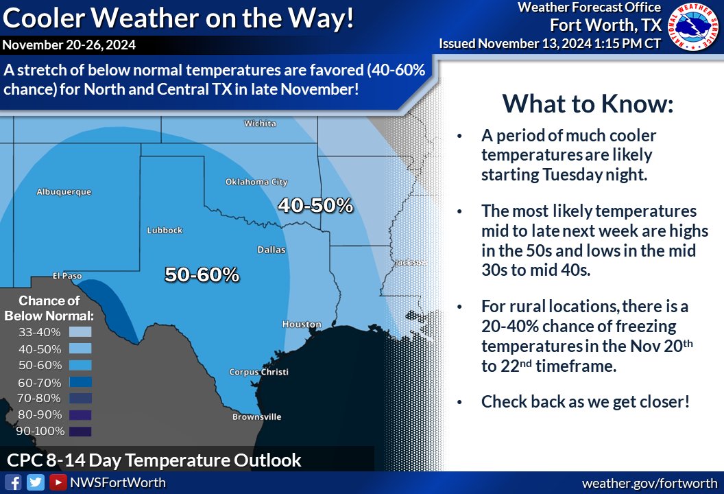
A period of much cooler temperatures is likely beginning Tuesday night. Most likely temperatures over the latter half of next week are highs in the 50s and lows in the 30/40s. Make sure to check back over the coming days for new forecast updates! #dfwwx #ctxwx
The end of the week will be quite pleasant with a warming trend over the weekend. Rain chances arrive by Sunday and continue into the midweek with the arrival of cooler temperatures! #dfwwx #ctxwx #txwx

Come help us make UNT safer! Our annual Safety Walk divides UNT into zones and volunteers help us identify spots that need better lighting or fixes. Join us Nov. 14th at 6:30pm by the fountain at the Library Mall. RSVP to Sgapresident@unt.edu!

11/8 2:40PM - a severe storm capable of 65 mph winds and small hail is currently moving into Montague County. If you are in the way of this storm, get inside a sturdy structure and avoid windows. #txwx #dfwwx
Both #UNT campuses in Denton and Frisco are under a Tornado Watch. Be #WeatherAware, know your shelter location, and have multiple means of receiving emergency alerts. Remember, if a tornado WARNING is issued, take cover! Visit weather.gov/fwd for more information.

The #UNT campus in Denton, is under a Flash Flood Warning. Remember, never drive or walk over flooded roadways or walkways! Always turn around, don’t drown! Visit weather.gov/fwd for more information.

The #UNT campus in Denton is now under Severe Thunderstorm Warning! Hail and strong winds are the main threats. Take action: Seek shelter inside a sturdy building. Visit weather.gov/fwd for more information.

Isolated strong to severe storms will remain possible across western North and Central Texas through the overnight hours tonight. Large hail, frequent lightning, and heavy rain will be the main threats with this activity. The best storm coverage will be along/west of I-35. #txwx

Due to larger than normal crowds expected for Saturday's football game against Army, please note that all lots - even Lot 20 Residents - must be cleared by 6 am on game day. Full details here: transportation.unt.edu/news.html#nov9…

Getting those weekend plans ready? 🗒️🍂 This is what you need to know! After the rain moves east on Saturday.... nice and pleasant conditions will persist thru Veteran's Day with highs in the 70s! 😎 #dfwwx #ctxwx

Today is the Day! Join us and @NWSFortWorth for our Winter Weather Seminar and learn some tips to keep yourself prepared during winter weather and be #MeanGreenReady

Both #UNT campuses in Denton and Frisco are under a Tornado Watch. Be #WeatherAware, know your shelter location, and have multiple means of receiving emergency alerts. Remember, if a tornado WARNING is issued, take cover! Visit weather.gov/fwd for more information.

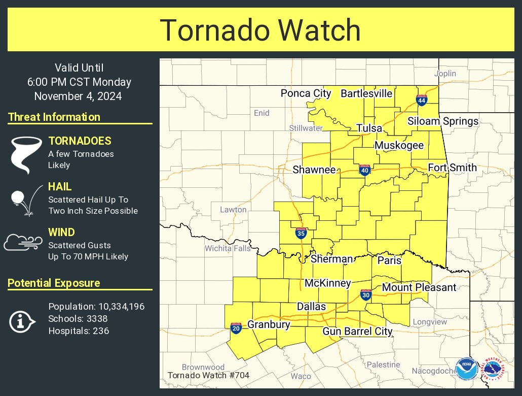
A Tornado Watch is in effect for the shaded areas until 6 PM. Main concerns will be large hail, damaging winds up to 70 mph, and a few tornadoes. Have multiple ways to receive warnings and be prepared to take shelter if a warning is issued for your location. #dfwwx #ctxwx

A tornado watch has been issued for parts of Oklahoma and Texas until 6 PM CST
An active weather pattern will bring multiple rounds of showers and storms to the region this weekend into early next week. Some storms will be capable of producing heavy rain, hail, and damaging wind gusts, especially along/north of I-20. Stay weather aware the next few days!


Heads up, UNT! 🌧️ Heavy rainfall and storms capable of producing hail and damaging wind gusts will be possible at times this weekend, with the best potential along/north of I-20.

United States Trends
- 1. Thanksgiving 1,61 Mn posts
- 2. Caleb Williams 13,4 B posts
- 3. Bears 84,7 B posts
- 4. Bears 84,7 B posts
- 5. Keenan Allen 4.939 posts
- 6. $VSG 8.711 posts
- 7. DJ Moore 4.437 posts
- 8. #CHIvsDET 11,5 B posts
- 9. Gibbs 18,2 B posts
- 10. #VECTOR 1.538 posts
- 11. Thankful 546 B posts
- 12. Shaboozey 5.819 posts
- 13. Jamo 5.200 posts
- 14. Ben Johnson 4.202 posts
- 15. #IDEGEN N/A
- 16. Turkey 336 B posts
- 17. Eberflus 9.131 posts
- 18. Jameson Williams 2.624 posts
- 19. Laporta 7.579 posts
- 20. #OnePride 11,4 B posts
Who to follow
-
 University of North Texas
@UNTsocial -
 UNTEagleAlert
@UNTEagleAlert -
 UNT Student Activities
@UNTActivities -
 Harrison Keller, Ph.D.
@UNTPrez -
 UNT News
@UNTnews -
 UNT Police Dept.
@UNTPolice -
 UNT Facilities
@UNTFacilities -
 UNT Student Affairs
@UNT_DSA -
 UNT CLASS
@UNTclass -
 Barnes & Noble @ UNT
@BNatUNT -
 UNT Dining Services
@UNTdining -
 UNT Union
@UNTUnion -
 UNT Transportation
@UNTtransit -
 UNT Advancement
@UNTAdvancement -
 UNT UPC
@UNT_UPC
Something went wrong.
Something went wrong.


