Manos Lagoudakis
@MLagoudakisPhysical Geographer, working with satellite images for the European Space Agency. Views are my own.
Similar User

@craigdonlon

@BrockmannCon

@PaulCounet

@paoberrett

@SimoneMantovan3

@EODetective

@space4env

@ThomasOrmston

@NatassaAntoniou

@cavrinceanu

@SteliosBollanos

@PaoloCipollini

@marielpvb

@vynicioalv
Colorado (US) was hit by one the heaviest November snowfall in decades last week when about 50 cm of snow fell on the region, completely transforming how it looks from space: ⬅️ Colorado on 13 September ➡️ Colorado on 11 November (after the snow) The September image was one…


And here's a map showing the distribution of the European beech, or Fagus Sylvatica, in Europe. As shown, the beech can be found from southern Scandinavia to southern Italy and from Spain to northwestern Türkiye. The highest probability of it being present is highlighted in…

Autumn colours from space🍂 This compilation of images, captured by @CopernicusEU #Sentinel2, showcases the characteristic hues of autumn in Italy, Greece and Romania.


Did you know that Antarctica has volcanoes? At the centre of this image we can see the active volcano Mount Erebus. The jagged edges of the Erebus ice tongue can be seen stretching out into McMurdo Sound.

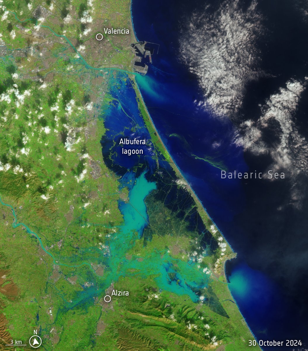
Spain is suffering its worst flood in decades after torrential rains struck the eastern province of Valencia. The death toll is climbing and people remain missing. 📸These images from Landsat-8 satellite illustrate the scale of the disaster, with images from October 8 and…

Revealing the secrets of intertIdal seagrass is now easier, thanks to @CopernicusEU #Sentinel2 data: A recent study used satellite data to map intertidal seagrass meadows and their seasonal changes across continents with consistency and precision. The outcome? The research…
A years worth of lava flow
A year of battling 🌋 lava: these @CopernicusEU Sentinel-2 images show the new lava fields that have formed near Grindavik in Iceland's Reykjanes Peninsula. The first image, acquired on 13 September 2023, pictures the town of Grindavik and surroundings before several eruptions…
New satellite in space➡️ new images! Here's a stunning set of images from the recently launched @CopernicusEU #Sentinel2 C satellite: 📸Seville 📸Belize and the Great Blue Hole 📸A long strip that stretches from the Camargue and Montpellier in southern France all the way down…


A giant jellyfish or a river delta? The Mahajamba Bay, also known as Helodrano Mahajambe, lies in northwest Madagascar at the confluence of two major rivers. Why is it orange? Its reddish-coloured water is caused by sediment from upstream. During heavy rain, the bright red…

Once again, the Brunt iceshelf has some breaking news: as these two satellite images show, a new iceberg detached from the shelf on 22 May. This is the the third significant iceberg calving from this region in the past four years. 👈 radar image by @CopernicusEU #Sentinel1…


Blink and you'll miss it! On 18 May, a meteor burned up in the night sky over Spain and Portugal – it was also caught by the Lightning Imager on the Meteosat Third Generation Imager satellite far away in geostationary orbit. Credits: @esa / @eumetsat
Wildfire season has arrived in full force in Canada, prompting evacuation orders and alerts in several towns in British Columbia and Alberta. According to a recent news by @CopernicusECMWF, total estimated carbon emissions from wildfires from 1 to 15 May amount to around 15…
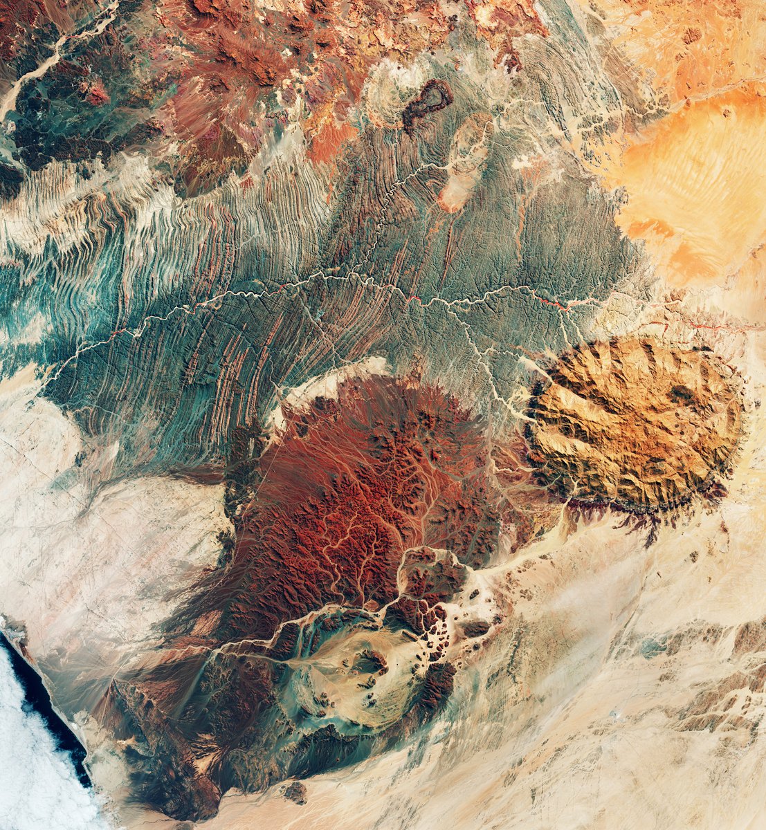
One satellite image and so many interesting spots! ⛰️One of the highest point in Namibia (Brandberg Massif) 🌋The ring-shaped Messum Crater, part of a collapsed volcano ☄️The Doros Crater, formed by a meteor impact event esa.int/ESA_Multimedia…
Despite current @ITU rules on use of the electromagnetic spectrum, satellites sometimes suffer from interference – radio frequency interference, or RFI. This can mean loss of data, risk of damage to the satellite receiver and biased or uncertain measurements. The animation…
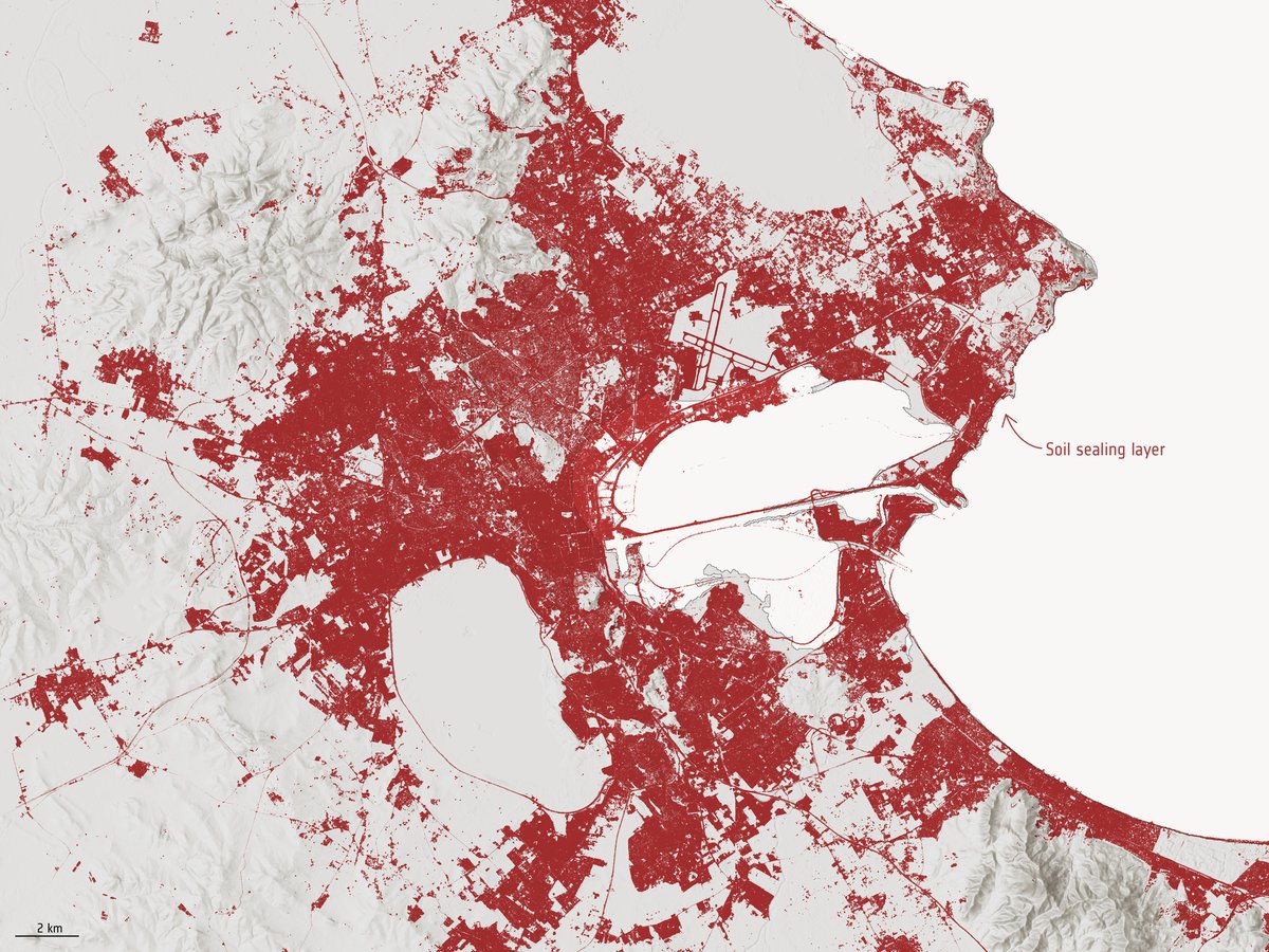
What's soil sealing? Soil sealing happens when soil surfaces are covered by impermeable materials and can contribute to environmental problems such as flooding, soil erosion, loss of biodiversity and decreased soil fertility. 📸 @CopernicusEU #Sentinel2 esa.int/ESA_Multimedia…

The electromagnetic spectrum is fundamental to observing Earth from space – all satellites use it in one way or another. But it's also a finite commodity, that we share with many other man-made devices on Earth. This means that satellite sensors can be affected by…

When the city of New York decided to complete the restoration of Beach 108th Street, a popular Rockaway Beach corridor in Queens, after it was destroyed by Storm Sandy in 2012, they did it with a new kind of porous pavement. This will allow rain water to be absorbed back into…


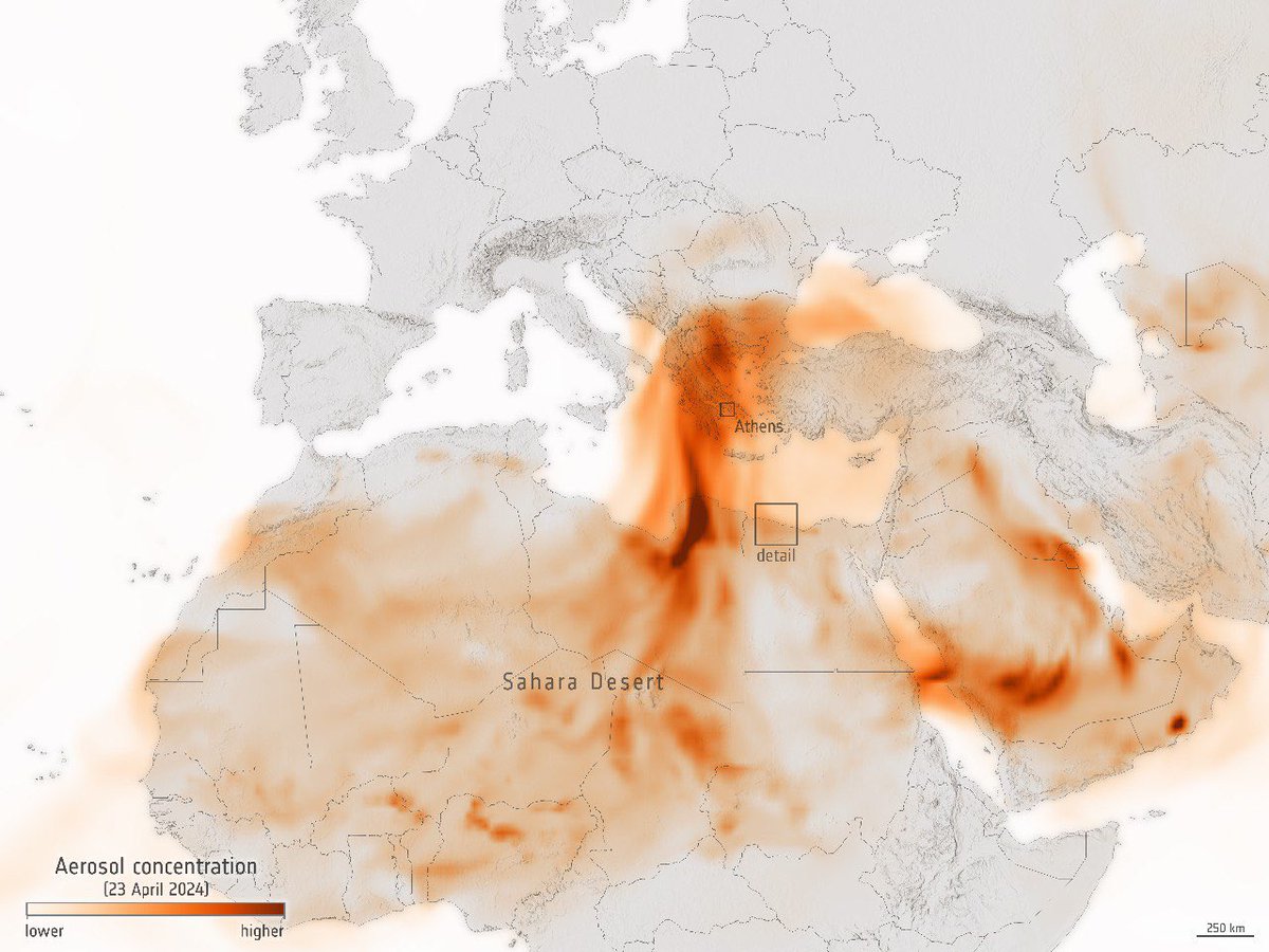
Since yesterday the sky over some countries of the eastern Mediterranean Sea has been looking orange. Why? Saharan dust! ⬅️As this @CopernicusECMWF aerosol forecast shows, a thick plume of Saharan dust has arrived in the area, giving the skies a Martian look. ➡️ A…

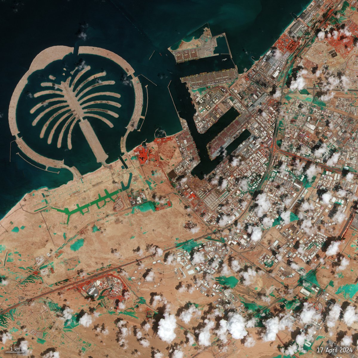
A @CopernicusEU #Sentinel2 image of #DubaiFlooding - captured yesterday 17 April. It's a false colour composite which highlights flooded areas in turquoise. Red patches in the image indicate vegetation. Click on the link below to explore this image at its full 10 m resolution:…
A clear winter day over the island of Ireland! ☁️ This (almost) cloud-free image was captured by @CopernicusEU #Sentinel3 in January 2024. 📸esa.int/ESA_Multimedia…

United States Trends
- 1. Browns 98,6 B posts
- 2. Lakers 51,6 B posts
- 3. Jameis 49,9 B posts
- 4. Franz 17,4 B posts
- 5. Bron 15,2 B posts
- 6. #ThePinkPrintAnniversary 23 B posts
- 7. Tomlin 20,5 B posts
- 8. Reaves 7.373 posts
- 9. Pickens 16,2 B posts
- 10. Pam Bondi 243 B posts
- 11. Anthony Davis 3.767 posts
- 12. #TNFonPrime 5.938 posts
- 13. #PinkprintNIKA 10 B posts
- 14. Chris Brown 18,6 B posts
- 15. #PITvsCLE 11,7 B posts
- 16. Russ 37,3 B posts
- 17. Arctic Tundra 14,8 B posts
- 18. #LakeShow 5.210 posts
- 19. Fields 52,1 B posts
- 20. Myles Garrett 9.774 posts
Who to follow
-
 Craig Donlon
@craigdonlon -
 Brockmann Consult
@BrockmannCon -
 Paul Counet
@PaulCounet -
 Paola Berretta
@paoberrett -
 Simone Mantovani
@SimoneMantovan3 -
 EODetective
@EODetective -
 space4environment
@space4env -
 Thomas Ormston
@ThomasOrmston -
 Natassa Antoniou
@NatassaAntoniou -
 Cris🛰️
@cavrinceanu -
 Stelios Bollanos
@SteliosBollanos -
 Paolo Cipollini 🇪🇺🇮🇹🇬🇧
@PaoloCipollini -
 Mariel Vilchez Bournigal de Dickson
@marielpvb -
 Vinicio Alvarado
@vynicioalv
Something went wrong.
Something went wrong.

