Tornadofinder
@JEM50954567future meteorologist/storm chaser Instagram- Tornadofinder
Similar User

@StormChaserChad

@cyclonePORT

@StormChaserWX1

@wxcorey

@daviswxnet

@HeathChases

@drew_richards

@TheWXStore

@LibbeyDean_

@katty0294

@thecomfortbears

@stormmoss

@angiehilburn1

@ryanhickman

@K707Wx
Hurricane Helene was the strongest hurricane to make landfall in the US this year and produced record-breaking storm surge.
This is either going to be a major model flop, or something truly historic is about to go down.


Here is a complete satellite loop of today's eclipse from our GOES-16 satellite! #gawx
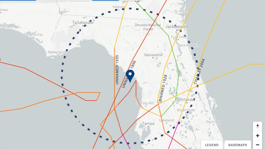
This should be the message. Since 1851, there has NEVER been a major hurricane landfall between Apalachicola and Cedar Key. (There has also not been a cat 4+ landfall in the Nature Coast either). This is the LAST DAY to prepare for something unseen. From @NWSTallahassee #Idalia

People think of Florida as being used to hurricanes. It's true there have been a large number, but this region is in a long drought. The last major hurricane to hit the Big Bend was in 1896. There isn't much knowledge of what such can do in that region. #Idalia #FLwx
Unpopular opinion : Jurassic world Dominion would have been 10x better if they killed off one of the OGs
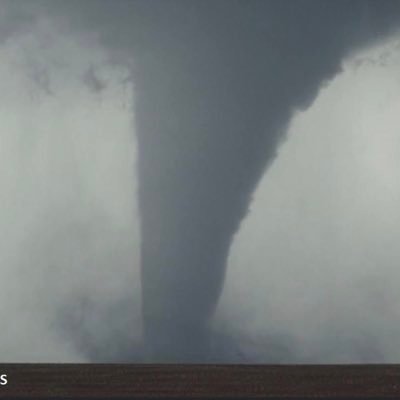
Absolutely incredible storm in Oklahoma! @BluekandyWX @ryanhallyall

Very strong #Tornado near Newton Georgia today ripping up trees and tossing them hundreds of feet into the air! This is most likely the strongest point of its lifecycle. #gawx #wxtwitter @DJIGlobal @ReedTimmerAccu @Sierra_Lindsey3
Tornado Warning including Mayo FL, Foley FL and Athena FL until 4:30 AM EDT

A tornado watch has been issued for parts of Oklahoma and Texas until 10 PM CDT

As an employee of @tacobell I would like to ask the higher ups to give storm chasers either a discount, or their meals for free while they are on the road. They have an incredibly important job that doesn't always pay. Like and retweet if you agree
One year ago tonight, I blasted north out of an Oklahoma cap-bust, and saw a weird storm so some weird stuff in Andover, KS. Full video in the comments⤵️
Dominator 3 is alive. Heading to North Texas for Tuesday
Living a Christian life isn’t about hustling 24/7, it’s about living for Jesus, not this world. Don’t let anyone make you feel guilty or embarrassed by prioritizing Christ over worldly success. This place is only temporary. Heaven is worth your focus and determination.
never stop chasing
i love watching the OG stormchasers so much, but it hurts so much every time i see tim samaras. RIP tim samaras
April 9, 1953: A hook echo was seen on radar for the first time; it was captured as a #tornado passed near Champaign, IL. The SPC lists this as an F3 that moved for 156 miles through IL & IN. Photo via the Illinois State Climatology Office. stateclimatologist.web.illinois.edu/2015/04/09/on-… #ilwx

Thank you, Jesus, for carrying my cross.
Death could not hold Him.
United States Trends
- 1. Kendrick 542 B posts
- 2. #AskShadow 19,2 B posts
- 3. $CUTO 7.147 posts
- 4. Luther 42 B posts
- 5. Drake 77,9 B posts
- 6. Daniel Jones 45,1 B posts
- 7. Wayne 53,9 B posts
- 8. MSNBC 179 B posts
- 9. Kdot 8.743 posts
- 10. TV Off 34,3 B posts
- 11. Squabble Up 25,1 B posts
- 12. Giants 77 B posts
- 13. Dodger Blue 12,9 B posts
- 14. LinkedIn 38,3 B posts
- 15. Reincarnated 32,9 B posts
- 16. NASA 69,6 B posts
- 17. #BO6Sweepstakes N/A
- 18. Kenny 24 B posts
- 19. Gloria 45,9 B posts
- 20. Jack Antonoff 8.145 posts
Who to follow
-
 StormChaserChad
@StormChaserChad -
 cyclonePORT
@cyclonePORT -
 TRD Pro Storm Chaser
@StormChaserWX1 -
 Corey Ecton
@wxcorey -
 Davis WXNet - Red Level, AL ⛈️
@daviswxnet -
 Heath
Heath
@HeathChases -
 Follow @DrewRichardsWX
@drew_richards -
 🌪️ The WX Store🌪️
@TheWXStore -
 Libbey Dean
@LibbeyDean_ -
 Kathleen Brooks (Kat chases)
@katty0294 -
 Comfort Bears
@thecomfortbears -
 Michael Wade Moss
@stormmoss -
 Angelique Hilburn
@angiehilburn1 -
 Ryan Hickman
@ryanhickman -
 Keenan
@K707Wx
Something went wrong.
Something went wrong.


