Similar User

@catlibertawx

@ElyMillardwx

@danielle__wx

@wxrachmoss

@lexdringuswx

@sampattersonwx

@ChristineGwx

@AndrewMP2

@SchoolSpirit345

@JackReed_Wx

@KWelch7

@DrakeFoleyWX

@CollinMertzWX
Despite yesterday's beneficial rainfall, Kansas continues to face a significant precip deficit. Most of eastern KS is still several inches below average over the past 4 months. As we enter our driest season, a lot more moisture is needed to alleviate the ongoing #drought. #kswx

Topeka just set a new record for the warmest temperature on record this late in the year! 🔥 The heat is fueling a risk of scattered thunderstorms early this evening, a few of which may be strong with gusty winds and hail. #kswx #topeka #recordheat

In spirit of the season's first freeze this morning, here is a look back at the 10 "worst" winters on record in Topeka. The list comes from a custom ranking methodology that incorporates many temperature and snowfall statistics. Are you ready for winter? #winter #kswx #topeka

I led one final tour of @NWCNorman today, nearly 12 years after I first toured the building. I have loved meeting prospective students and their families, as well as so many others interested in learning about the weather from all over the country.


10:15 PM: A significant flash flooding threat is likely to develop in Pottawatomie County and surrounding areas over the next few hours as thunderstorms train. #okwx
Central Oklahoma: The tornado threat is quite limited for the rest of the night in the OKC metro. Most areas will see rain but not significant severe weather. #okwx
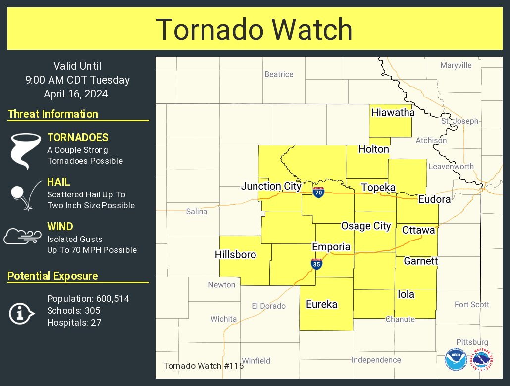
A tornado watch has been issued for parts of Kansas until 9 AM CDT
The total solar #eclipse will have a wide range of impacts to #weather on Monday! Temperatures will fall, especially where the sky is mainly clear. Winds near the surface will weaken. Cumulus clouds may dissipate. Most weather models (except the HRRR) do NOT account for eclipses!
Discussion regarding potential for severe thunderstorms for portions of the Mid-Atlantic. The solar eclipse = cooler temps = less threat.
We have issued a Campus Weather Alert Day for the risk of severe weather in Norman later today. The most likely time for storms on campus is between 4 and 8 PM. The main hazard will be very large hail up to baseball size. Strong wind gusts and a few tornadoes are also possible.
2023 goes down as the warmest and driest year of the past decade in Topeka. We hope for more moisture in the year ahead! #kswx

A strong storm system will bring rain to eastern Kansas on Sunday. Then, an impactful winter storm will evolve across the Plains on Monday. A Christmas blizzard is becoming likely for central Nebraska. Farther south, light snow will be possible with less accumulation. #kswx #newx

Although temperatures will be much above average in the days leading up to Christmas, a lack of sunshine and occasional chances of rain in KS will help keep a bit of a festive chill in the air. Here's the forecast for Topeka:

BREAKING: The official snowfall total at Billard Airport in Topeka is 7.2", making this the biggest two-day snowstorm in the Capital city since February 4-5, 2014, when 13.0" fell over NINE YEARS ago! #kswx #snow

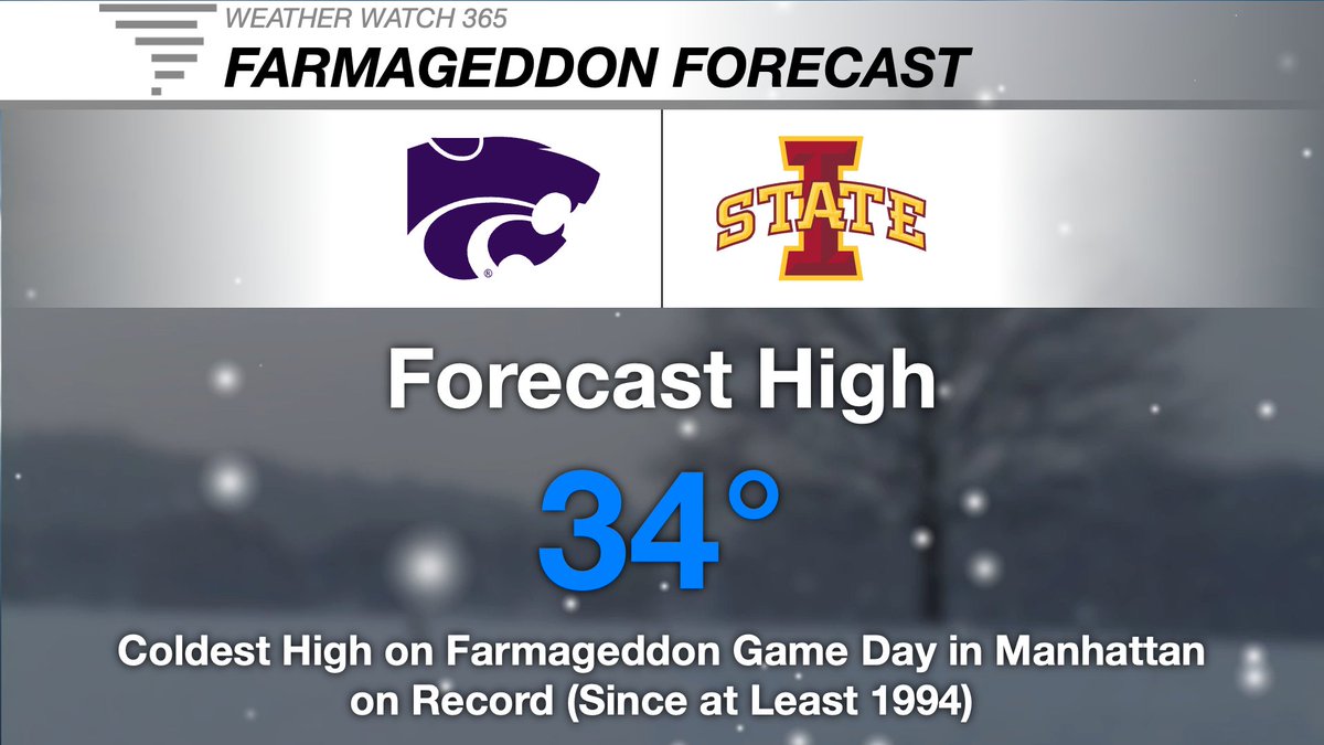
This is forecast to be the coldest high temperature on Farmageddon Game Day @KState since at least 1994, before weather records began in Manhattan. The coldest to date was in 2015 with a high of 40°. Snow is also expected during the game. #kswx #KStateFB #recordcold #snow
Truly cold air is FINALLY coming! Here's my full forecast from OU Nightly today: youtu.be/8q1zanUH2_s?si… #okwx
ANOTHER FREEZE LIKELY: Although lows are forecast to remain just above freezing in Topeka over the next couple of days, another blast of colder air is expected to arrive by next weekend with morning temperatures below 32° possible! #kswx

United States Trends
- 1. Dalton Knecht 46,7 B posts
- 2. Lakers 61,4 B posts
- 3. #LakeShow 5.589 posts
- 4. Jay Leno 4.209 posts
- 5. $QUANT 11,5 B posts
- 6. Hampton Inn 1.842 posts
- 7. Spurs 17,2 B posts
- 8. Jaguar 118 B posts
- 9. #DWTS 26,8 B posts
- 10. Linda McMahon 43,4 B posts
- 11. #RHOBH 11 B posts
- 12. Celtics 59,8 B posts
- 13. Dorit 5.513 posts
- 14. Chris Paul 3.000 posts
- 15. Cenk 31,1 B posts
- 16. Chase U 6.128 posts
- 17. Reaves 5.576 posts
- 18. Cavs 52,6 B posts
- 19. Tatum 35,1 B posts
- 20. Marquette 5.355 posts
Who to follow
-
 Catherine Liberta
@catlibertawx -
 Ely Millard
@ElyMillardwx -
 Danielle Crutchfield
@danielle__wx -
 Rachael Mosshammer
@wxrachmoss -
 Alexa Dringus
@lexdringuswx -
 Sam Patterson
@sampattersonwx -
 Christine Gormley
@ChristineGwx -
 Andrew Patton
@AndrewMP2 -
 Mike Monaghan
@SchoolSpirit345 -
 Jack Reed
@JackReed_Wx -
 K Welch
@KWelch7 -
 Drake Foley
@DrakeFoleyWX -
 Meteorologist Collin Mertz
@CollinMertzWX
Something went wrong.
Something went wrong.


