Cecily Tynan
@CecilyTynanAction News chief meteorologist, tournament slalom water skier, wife and mother of two fantastic teenagers and two sweet pups. (Retweets are not endorsements.)
Similar User

@6abcadamjoseph

@Jim_Gardner

@6abcWeather

@6abc

@aliciavitarelli

@chris_sowers

@BobKellyFOX29

@KathyOrrFOX29

@FOX29philly

@briantaff6abc

@PhillyPolice

@karenrogers6abc

@MikeFOX29

@rickwilliams6

@PhillyDailyNews
Honored to be the cover feature for @realwomanonline We are so lucky to have a local magazine aimed at inspiring & empowering women from all backgrounds! Here’s a link to the article: realwomanonline.com/the-life-caree…

WEEKEND FORECAST Temperatures will be several degrees above average, but gusty winds on Saturday will make it feel cooler and pose a wildfire threat. By late Sunday skies will be turning a milky white thanks to high cirrus clouds moving in.

FRIDAY'S PLANNER The day starts out with lots of clouds, but they break up through the morning and sunshine returns for the afternoon. That sunshine allows the atmosphere to get well mixed and breezy conditions with gusts to 25mph will develop.

The full moon on Friday has resulted in higher astronomical tides, with minor tidal flooding ongoing this morning. Expect minor tidal flooding around the time of high tide through Friday, potentially into Saturday. Tide levels may even hit moderate tomorrow morning in some spots.


THURSDAY NIGHT FOOTBALL The @Eagles will have a chilly night with temperatures falling through the 40s. There is a very small chance of a shower. Dress warmly if you are heading to the game.

TRACKING SHOWERS An area of low pressure will head toward us tomorrow, but it will be hitting a wall of dry air. A few showers are likely in the western and southern suburbs, but from Philadelphia on northeast we will be hard pressed to see a sprinkle or two.

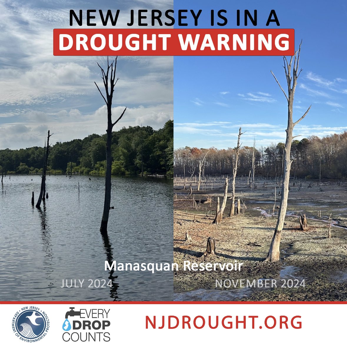
⚠️ New Jersey is currently in a drought warning. Since June, NJ has seen 6-11 inches LESS rain than normal. Help us conserve water with these tips 👇 💧Take five-minute showers 💧Only run a load of laundry or dishes when full 💧Turn off the water when brushing teeth 💧Install…
MIDWEEK PLANNER This will be our coolest day since back in spring. After starting near freezing we only top out in the low 50s--about 5 degrees below average. At least we will have abundant sunshine and much lighter winds than today.

We’re featuring 9 month old lab/hound mix Bodie on #shelterme @6abc Friday 10AM/noon. Hoping he finds a fantastic forever home in record time! #AdoptDontShop #greatpup

COLDEST THIS FALL Temperatures will drop into the 20s for most suburbs and to 34 here in Center City making it the coldest since back on March 25th.

WINDY TUESDAY A secondary cold front will move through before sunrise and winds will pick up behind it with gusts of 30-35mph for much of the day. This combined with very dry air will once again lead to an enhanced risk of wildfire spread.

BACK TO REALITY After 5 of the last 7 days with highs between 12 to 20 degrees above average we are in for quite a reality check. Each of the next 3 days look to be close to seasonable levels with highs only in the low to mid 50s.

Looking forward to breaking the rain-free streak tonight!
As of Sat. here are the streaks of days without measurable precipitation: ABE 16 days ACY 38 days - record longest MPO 26 days - tied for 2nd longest PHL 42 days - record longest RDG 16 days TTN 42 days - record longest ILG 42 days - record longest GED 43 days - record longest
MUCH NEEDED RAIN Our first measurable rain in over 40 days will arrive Sunday evening and last into the night. We are expecting around 1/4" of rain out of this so not a lot, but any amount helps at this point. Another chance of rain comes on Thursday.

GUSTY WINDS Wind gusts near 30mph continue this afternoon and the red flag warning remains in place until 6pm. While winds do lessen overnight and for tomorrow it will stay breezy and an enhanced fire danger will continue into the early weekend.

WEEKEND FORECAST After record breaking temperatures in the 70s and 80s for much of the week we will see a drop to more seasonable numbers for the weekend. We also look to have our first measurable rain in over 40 days!

DROUGHT MONITOR Today's update shows the first extreme drought area in parts of South Jersey in 22 years. About 95% of our viewing area is now in a severe drought or worse. Rainfall deficits over the last 3 months across the region are between 8" and 11".

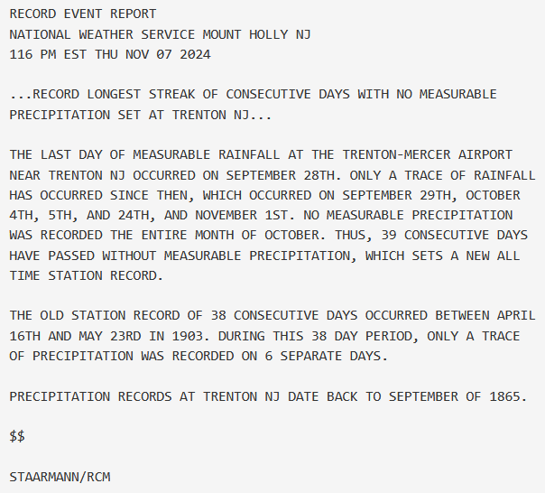
The record at Trenton has fallen.
Beautiful!
Drone view this afternoon of a warm fall day today above Fairmount Park and Boathouse Row in Philadelphia! @myphillypark @PhilaParkandRec @philamuseum @visitphilly @6abcWeather @discoverPHL @ccdphila @PaytonDomschke @philaculture @philartdotnet @DJIGlobal

No #IVoted sticker for me. My polling place ran out of stickers before noon. Glad to hear so many of my neighbors are voting, too! #ElectionDay
United States Trends
- 1. $MAYO 9.810 posts
- 2. $CUTO 7.480 posts
- 3. Tyson 382 B posts
- 4. Pence 43,3 B posts
- 5. Laken Riley 37,5 B posts
- 6. Dora 22 B posts
- 7. Ticketmaster 16,1 B posts
- 8. Mike Rogers 7.711 posts
- 9. Kash 69,5 B posts
- 10. Cenk 10,3 B posts
- 11. Pirates 18,4 B posts
- 12. #FursuitFriday 15,4 B posts
- 13. #LetsBONK 5.096 posts
- 14. Mr. Mayonnaise 1.362 posts
- 15. The UK 427 B posts
- 16. Iron Mike 15,7 B posts
- 17. Debbie 14,5 B posts
- 18. Scholars 10,6 B posts
- 19. Al Gore 3.221 posts
- 20. DeFi 103 B posts
Who to follow
-
 Adam Joseph
@6abcadamjoseph -
 Jim Gardner
@Jim_Gardner -
 6abcWeather
@6abcWeather -
 Action News on 6abc
@6abc -
 Alicia Vitarelli
@aliciavitarelli -
 Chris Sowers
@chris_sowers -
 Bob Kelly
@BobKellyFOX29 -
 Kathy Orr
@KathyOrrFOX29 -
 FOX 29
@FOX29philly -
 Brian Taff
@briantaff6abc -
 Philadelphia Police Department
@PhillyPolice -
 Karen Rogers
@karenrogers6abc -
 Mike Jerrick
@MikeFOX29 -
 rick
rick
@rickwilliams6 -
 Philly Daily News
@PhillyDailyNews
Something went wrong.
Something went wrong.


