Town of Barnstable
@BarnstableMAWelcome to the Town of Barnstable's official Twitter page! Follow us to get updates about the town.
Similar User

@CapeCodcom

@CapeCodLife

@capecodtimes

@CapeCodGov

@CCCNewsroom

@VisitCapeCod

@FalmouthChamber

@ccDailyDeal

@TownofDennis

@CCCommission

@95wxtk

@ccmnh

@CapeMediaNews

@CapeAbilities

@TownofPT
Thank you to our many brave firefighters and first responders who are working to protect our communities from fire danger. We can all do our part to prevent new fire risks by taking simple precautions. Learn more at mass.gov/info-details/o….

🔥 High Fire Danger Alert! 🔥 With elevated fire risk this weekend, we’re urging everyone to limit outdoor ignition sources. Please avoid activities that could spark a fire, like open flames or using outdoor equipment that generates heat.

ELECTION NOTICE: Some important deadlines coming up ahead of the November 5th Presidential Election. FRIDAY, NOVEMBER 1st marks the last day for early voting at 200 Main Street. MONDAY, NOVEMBER 4th marks the last day to apply in person for an absentee ballot.

Voting in Barnstable - Because your vote matters The last day to register to vote is October 26th at 5pm in the Town Clerks Office | 367 Main Street, Hyannis In person early voting starts SATURDAY October 19th from 8AM-12PM | 200 Main Street , Hyannis townofbarnstable.us/.../Election-I…

The latest Town of Barnstable news delivered to your inbox every Friday! conta.cc/4cIe8aJ
The latest update from @NWSBoston …
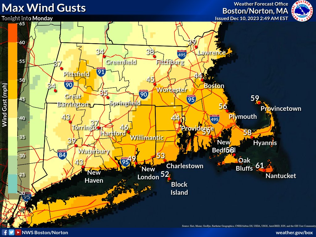
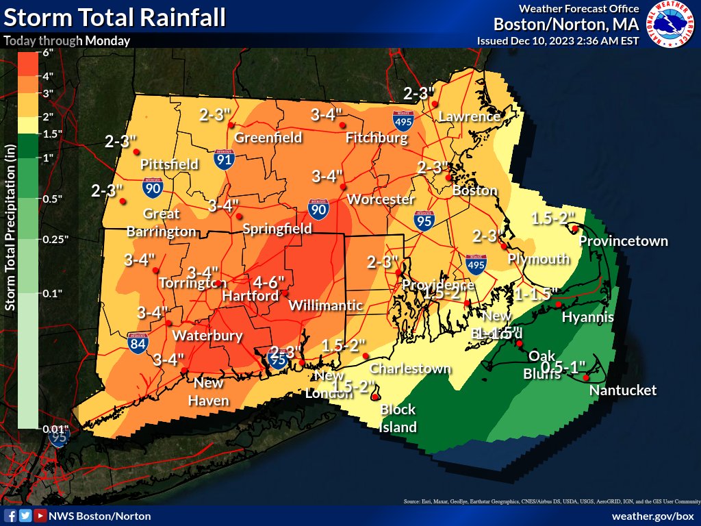
01/09/2024 AM - Latest forecast details in graphics! Check out max wind gusts, expected rainfall, and snowfall amounts. Stay informed about the upcoming weather: weather.gov/box #MAwx #CTwx #RIwx


Sharing the latest from @NWSBoston
Here is a loop of projected hourly #snowfall rates from 7 PM tonight to 7 AM Sunday. Moderate to heavy snow enters western MA/CT ~ 9-10 PM, then spreads eastward & exits eastern MA 6-7 AM Sunday. Hourly snowfall rates of 1-2" (green areas) are likely, hence difficult travel.
Sharing the latest from @NWSBoston …
[630 AM] A steady moderate to heavy rain this morning will transition to showers this afternoon. Street/highway flooding will continue along with strong to damaging winds. Strongest winds occur this morning into midday for #CapeCod & Islands. #MAwx #RIwx #CTwx
Here’s the latest update from @NWSBoston
Here's a look at what to expect over the next 24-36 hrs across SNE. Heavy rain will ramp up overnight. The greatest threat for damaging winds will be between 7 am and 2 pm tomorrow. Rapid improvement tomorrow evening will give way to scattered flurries and showers on Tuesday.
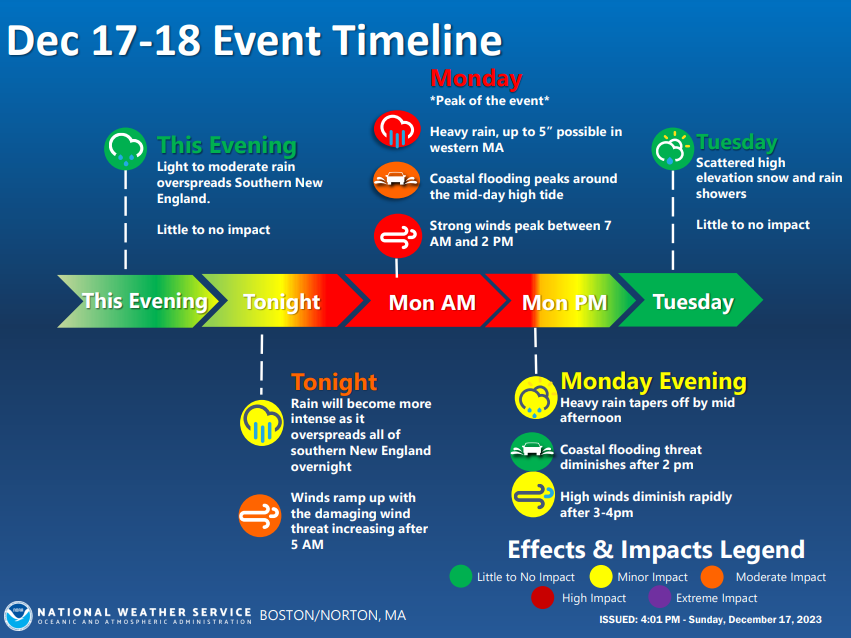
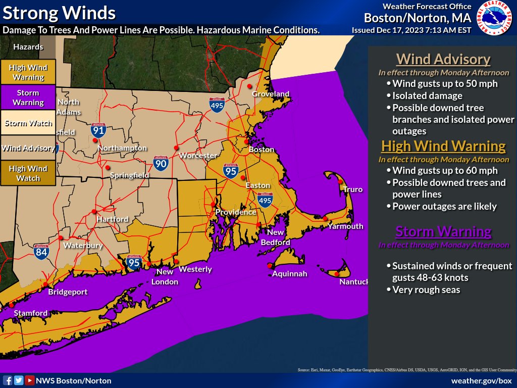
From @NWSBoston A strong storm system will bring heavy rain and high winds to southern New England early Monday. Gusty winds as high as 65mph could down trees and cause power outages.
Latest from @NWSBoston The main risk for strong to damaging wind this morning will be across Cape Cod and the Islands where S winds will gust to 50-60 mph before shifting to NW and diminishing.
The main risk for strong to damaging wind this morning will be across Cape Cod and the Islands where S winds will gust to 50-60 mph before shifting to NW and diminishing. Elsewhere, expect NW winds gusting to 25-35 mph today.

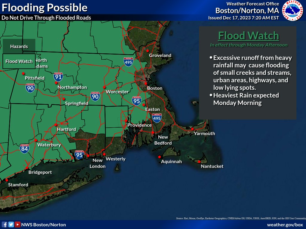
Here is an update from @NWSBoston for the strong storm that will bring heavy rainfall, possible flooding and strong winds to SNE later today into Monday morning.
Here is an update for the strong storm that will bring heavy rainfall, possible flooding and strong winds to SNE later today into Monday morning. In addition, areas of minor coastal flooding is likely for areas adjacent to Narragansett Bay.
United States Trends
- 1. Fauci 108 B posts
- 2. Spotify 2,84 Mn posts
- 3. Snape 5.339 posts
- 4. CEOs 30,8 B posts
- 5. Pete 925 B posts
- 6. #AbbottElementary N/A
- 7. Hawk Tuah 25,7 B posts
- 8. $HAWK 7.895 posts
- 9. $EMT 4.074 posts
- 10. Mbappe 174 B posts
- 11. #EarthMeta 1.670 posts
- 12. Sister Jean 1.184 posts
- 13. #TheMaskedSinger N/A
- 14. United Healthcare 99,8 B posts
- 15. Preemptive 41,2 B posts
- 16. Arsenal 429 B posts
- 17. Brian Thompson 173 B posts
- 18. UHC CEO 11,4 B posts
- 19. Citibike 13 B posts
- 20. Alan Rickman N/A
Who to follow
-
 CapeCod.com
@CapeCodcom -
 Cape Cod Life
@CapeCodLife -
 Cape Cod Times
@capecodtimes -
 Barnstable County Government
@CapeCodGov -
 Cape Cod Chronicle
@CCCNewsroom -
 Visit Cape Cod
@VisitCapeCod -
 Falmouth Cape Cod
@FalmouthChamber -
 Cape Cod Daily Deal
@ccDailyDeal -
 Town of Dennis
@TownofDennis -
 Cape Cod Commission
@CCCommission -
 NewsRadio 95 WXTK
@95wxtk -
 Cape Cod Museum of Natural History
@ccmnh -
 Cape Media News Sports
@CapeMediaNews -
 Cape Abilities
@CapeAbilities -
 Town of Provincetown
@TownofPT
Something went wrong.
Something went wrong.


