Google has developed a new AI-powered weather forecasting model called NeuralGCM. It combines traditional physics-based prediction methods with machine learning.

🚀 Introducing the Earth Engine Dataset Explorer, powered by Google #Gemini! 🌍✨ Struggling to find the right #geospatial datasets for your research? Our Dataset Explorer recommends tailored datasets and offers an interactive exploration experience. 📹 Check out the video…
میں نے 2024 میں 1000 سے زیادہ AI ٹولز آزمائے۔ 70% وقت کا ضیاع تھے۔ 20% میرے لیے غیر متعلقہ تھے۔ لیکن یہ 10 آپ کی زندگی میں انقلاب لا سکتے ہیں اور 10 گنا وقت بچا سکتے ہیں:

Mapping and Monitoring Urban Growth Using Remote Sensing: A Comprehensive Methodology for Change Detection and Analysis using #googleearthengine Tutorial Link: youtube.com/live/xk94iUs-H… Registration Info: studyhacksgeospatial.com/google-earth-e… #googleearthengine #gis #remotesensing #gee


What if you could make physics diagrams come alive? At #UIST2024, we will be presenting our paper, Augmented Physics, an ML-Integrated Authoring Tool for Creating Interactive Physics Simulations from Static Diagrams Co-authors: @Freya_Wyy @nandizhang_ Jarin @rubaiat @ryosuzk
#DataViz driving times🚗from New Delhi's Airport📍using #OpenSource data from @StadiaMaps & @ors_news, inspired from @milos_agathon Code & Interactive version🔗tinyurl.com/del-airport Tools @LeafletJS, #rstats, #ggplot2, #ggmap by @davidjkahle, #maptiles by @_rlg & @neocartocnrs

Serving a private Llama 3.2 RAG API is now easier than ever! You can deploy a RAG application behind a private API using LitServe in a framework-agnostic and fully customisable setup. We’ve used @vllm_project for efficient LLM serving and a self-hosted, high-performance…

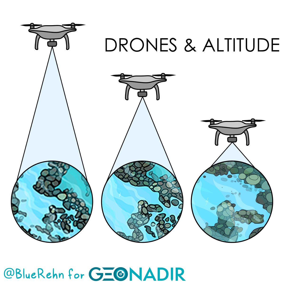
What's more important for your mapping mission - high detail or large area coverage? There's always a trade off! But rather than go with trial and error, here's an efficient way to work out what you need geonadir.com/optimal-drone-…

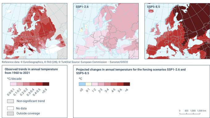
Did you know we can access 𝙙𝙖𝙞𝙡𝙮 geospatial climate projections up until 1 Jan 2100? It covers projections for: • temperatures • precipitation • snowfall Plus it's completely free. Here's what you need to know about it:

A (creepy?) new study uses social media and geospatial data to identify peoples' emotions in theme partks. How do they do this? By analysing people's facial expressions from social media posts. Here's the breakdown:

I'm 19. I’m obsessed with learning how to learn. So, I spent 300+ hours studying how geniuses, prodigies, and high performers master their disciplines. Here's what I found on how to master anything faster... 🧵(thread)

Thread of Cool Maps You've Likely Never Laid Eyes On 1. Europe in 1444

A simplified overview of brain function:

3. Merge Multiple PDFs into One 4. Split a PDF into Individual Pages

Introducing: the AI Georeferencer 🗺️ Our new QGIS add-on generates control points for raster maps automatically, using AI. Here's me georeferencing two maps in QGIS without ever manually adding a GCP:
United States Trends
- 1. $CUTO 8.050 posts
- 2. #JusticeforDogs N/A
- 3. ICBM 190 B posts
- 4. $EFR 2.210 posts
- 5. The ICC 258 B posts
- 6. Jussie Smollett 8.384 posts
- 7. Netanyahu 542 B posts
- 8. Denver 32,8 B posts
- 9. Illinois Supreme Court 8.298 posts
- 10. #KashOnly 41,9 B posts
- 11. Dearborn 6.879 posts
- 12. Volvo 6.276 posts
- 13. #ATSD 10,8 B posts
- 14. chenle 130 B posts
- 15. #AcousticGuitarCollection 2.383 posts
- 16. #AtinySelcaDay 10,4 B posts
- 17. Katie Couric 2.564 posts
- 18. Flat 51,1 B posts
- 19. Bezos 40 B posts
- 20. DeFi 123 B posts
Something went wrong.
Something went wrong.


