keith
@korubAvid cruise traveler, with over 90+ Voyages on numerous lines. Located in Ocean County, The Jersey Shore. Jersey Strong !!!!!
Similar User

@Sloppy_Otter

@WarLegalEagle

@Shgkrc

@akosimariwer
We Now Have Invest 98L and the Hurricane Hunters are scheduled to investigate later today to help with data for the Models. We are on the Anthem and still no updates???? It’s rather obvious it’s going to be impossible to Dock in CCY & Nassau with adverse Seas/Wind??
Happy Sunday @RoyalCaribbean Guest and Crew. Update on developing storm and what we are forecasting for this week for the Bahamas, Florida, and the Atlantic Coast up to Cape Hatteras. Graphics added (swipe after vid) for further details:


Canada’s cruising season just ended. Bermuda would be a better option. Docking space is available at the Dockyard.
Leaving on Anthem Sunday. Please , please 100x please do not send us North. I have zero clothing for that kind of deviation 😂😂
James the Anthem is scheduled to Visit PCC on Tuesday, CoCoCay On Wednesday & Nassau. Are you considering an ITIN Change due to possibly of the Tropical System in the area ????
Morning @RoyalCaribbean Guests. Gaining confidence on wind/swell around Bahamas/Florida from the pressure gradient between a front to the north and Low coming up from south. Spending today working with Captains on the storm, then coming to you all for weather update Sunday AM.


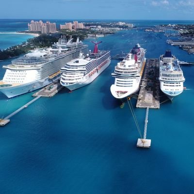
Anthem is enjoying today in CoCoCay.
For @RoyalCaribbean #IndependenceoftheSeas Guests: NE Swell, and wind gusts over 30mph are too much to safely hold on the Pier today in #CocoCay. Often that swell created from the high of wind in that direction can cause waves to crash over the Pier making it unsafe to walk on.


Current appointments start in Late March.
Dr., The Meaning of “mentsch” for your Gentile Twitter followers :):)
Noticed the same in the Brick/Wall area.
James, the Anthem is scheduled to call on CoCoCay, Tuesday. 20-25 Knot winds with 4’-6’ swells anticipated. This is not encouraging ??
I’m afraid Friday through Tuesday are looking worse for winds in the Bahamas and Florida too. Going to be along six days with these two systems.


Great to see you Back Cranky !!!
I’m afraid Friday through Tuesday are looking worse for winds in the Bahamas and Florida too. Going to be along six days with these two systems.


Russian BOT ??
BREAKING: George Nader and seven others charged with massive campaign finance scheme to donate to Hillary Clinton's 2016 campaign. Nader secretly bankrolled Khawaja's donations, feds allege: justice.gov/opa/pr/califor…
Bermuda has availability Monday evening into Thursday evening at Heritage wharf 🙄🙄🙄
For @RoyalCaribbean #AnthemoftheSeas Inbound Guests: We will have an update for you later today. Headed in to a meeting with the Ship at 9am and we will make a plan. Once meeting concludes it does take a few hours to write/send all messaging, but you should hear this afternoon.

James, what are the Plans for The Anthem Sailing To NE/Canada On Late Thursday afternoon ? Any deviation in schedule due to the forecasted offshore High Seas/Winds ?
For @RoyalCaribbean Guests in the Atlantic: Our Officers and Crew have been working with Miami HQ the last few days to create Navigational Plans. #AnthemoftheSeas is staying south before turning north, #GrandeuroftheSeas will transit south, then turn west in the days ahead.


Would CoCoCay be exposed to the 18’-22’ Storm surge on top Of the 25’~35’ swells in the general area ?? Also the tropical to Hurricane force winds ??
FYI - CocoCay is in the middle of my three lightning distance range rings.
TNX, Marc
TNX, Steve !!
Won't know for sure until tomorrow, but this would be like a strong Nor'Easter if it tracked close enough. Like extratropical or subtropical by then.
Won't know for sure until tomorrow, but this would be like a strong Nor'Easter if it tracked close enough. Like extratropical or subtropical by then.
Steve any concerns for us folks here at the Jersey Shore, as we have invalid parents residing in Coastal Ocean County.
Marc, nothing like Sandy Correct ??
Again we here in the Mid-Atlantic & NE have a chance to see outer edge of Rain/Wind as Dorian will eventually curve NE & over the Atlantic next weekend or so.


United States Trends
- 1. Kash 706 B posts
- 2. Good Sunday 38 B posts
- 3. #FayeYokoYentertainAwards 218 B posts
- 4. SPOTLIGHT COUPLE FAYEYOKO 220 B posts
- 5. #december1st 1.630 posts
- 6. Happy New Month 126 B posts
- 7. Wray 57,8 B posts
- 8. #FortniteChapter6 9.448 posts
- 9. McCabe 43,5 B posts
- 10. jeno 325 B posts
- 11. Fauna 93,8 B posts
- 12. #BYUFootball 1.096 posts
- 13. Houston 32,9 B posts
- 14. Iowa State 10,4 B posts
- 15. #LAGalaxy 2.171 posts
- 16. Bill Barr 10,1 B posts
- 17. Aggies 12,9 B posts
- 18. Ewers 10,5 B posts
- 19. Cyclones 3.096 posts
- 20. Hololive 43,4 B posts
Something went wrong.
Something went wrong.


