Quirinimbus
@QuirinimbusClimatólogo bípedo, sin plumas y pulgares opuestos.
Similar User

@MaingaMolina

@yenimonserrath1

@inesmotgz28

@NashPlash

@BrendaGlezR

@QuirinoDaniela

@Jjlino_

@CalsalCastillo

@_karlatellez

@gorettihdz
Aurora boreal en Sonora. 10/Oct/2024

🇺🇸Someone’s putting up a Trump flag on Naples Pier in Florida amid heavy winds and storm surge ahead of Hurricane Milton #HurricanMilton #HurricaneMilton #Milton #miltonhurricane #Milton #FloridaStorm
Mexico's Yucatan Peninsula were hit with strong winds and extensive flooding as a result of #HurricaneMilton #Milton #Hurricane #hurricanemilton #MiltonFlorida #florida #flwx #WeatherReady #Weather
The 👁️ of #hurricanemilton2024🌀 during a mission Oct. 8. Listen to local officials, evacuate if told to do so, and stay #weatherready

#FelizMiercoles 🇲🇽 ¿Cómo les trata la vida después de la toma de protesta de la 1° presidenta de México? A mí con mucho frío 🥶 🌀 Como ayer les dije, tenemos nuevo ciclón frente a #Oaxaca y al parecer, será un #John 2.0 PEEERO no porque vaya a tocar Acapulco de nuevo (al menos…


🌀🇲🇽 "Acapulco has been destroyed" For a second time after just 11 months.

Acapulco, México. Huracán Otis 2023/Huracán John 2024. Dos devastaciones en un lapso de 11 meses. ¿Cuán habitable es una ciudad tan expuesta a los impactos de la crisis climática? ¿Cuánta gente emigrará? ¿Quién invertirá ante tanto riesgo?


📷 “2 de octubres no se olvida” Ni perdón ni Olvido

MEXICO 🇲🇽 HURRICANE #JOHN Acapulco was once again the site of a terrible hurricane along the Mexican Pacific coast and forecast to go back to sea after reaching Puerto Vallarta. #Acapulco

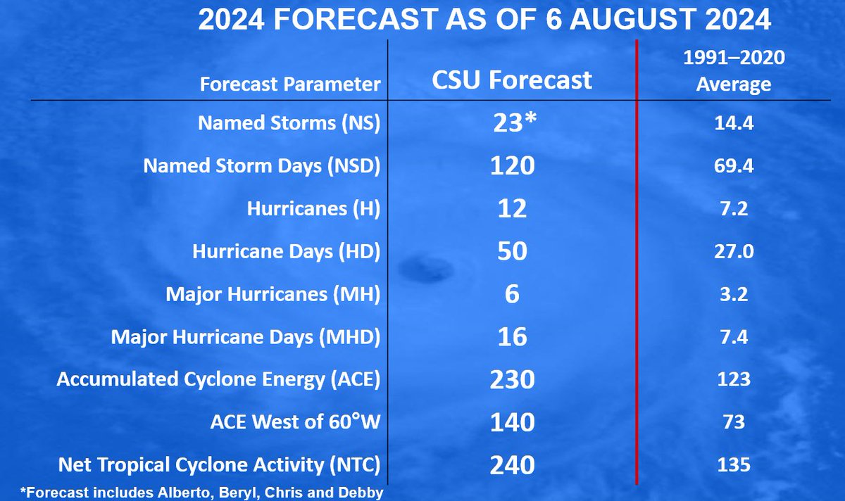
Colorado State University predicts extremely active 2024 Atlantic #hurricane season with 23 named storms (including Alberto, Beryl, Chris & #Debby), 12 hurricanes & 6 major hurricanes. Very warm Atlantic continues, while #LaNina/cool neutral ENSO likely. tropical.colostate.edu/Forecast/2024-…
La cara de los reyes de España cuando apareció María Antonieta decapitada, no tiene precio.


A closer look at radar as Typhoon #GAEMI neared Taiwan earlier this morning. This extreme loop prior to landfall is nearly identical to KROSA 2007, which looped to the south before pivoting back north, striking #Taiwan. I’d say there’s some sort of geography at play here, with…
putting the height in geopotential height
The 2024 Atlantic #hurricane season has already surpassed 30 ACE (Accumulated Cyclone Energy) - the fastest an Atlantic hurricane season has reached 30 ACE on record. Prior record holder was 1933, which reached 30 ACE on 6 July. ACE tabulates storm frequency, intensity, duration.
A look into the eye 👁️ of Hurricane Beryl today. Late Monday, Beryl became the earliest storm to develop into a Category 5 hurricane in the Atlantic, though it was downgraded Tuesday to Category 4. For up to date forecasts visit nhc.noaa.gov #hurricaneberyl


#Hurricane #Beryl is forecast to be at major (Category 3) hurricane strength when it tracks into the Caribbean in early July. Only two major hurricanes have occurred in the Caribbean prior to 1 August on record (since 1851): Dennis and Emily in July of 2005.
#Beryl is forecast to become a major (Category 3) #hurricane on July 1st. If it does so, it would be the 3rd earliest Atlantic major hurricane on record, trailing Alma (6/8/1966) and Audrey (6/27/1957).
#Hurricane #Otis has intensified by 80 mph in the past 12 hours (from 65 mph to 145 mph). That's the fastest 12 hr intensification rate in the eastern North Pacific (to 180°) in the satellite era (since 1966), breaking the old record of 75 mph/12 hr set by Patricia in 2015.

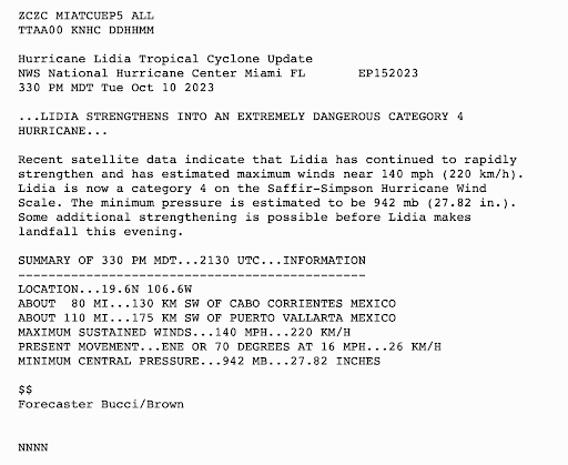
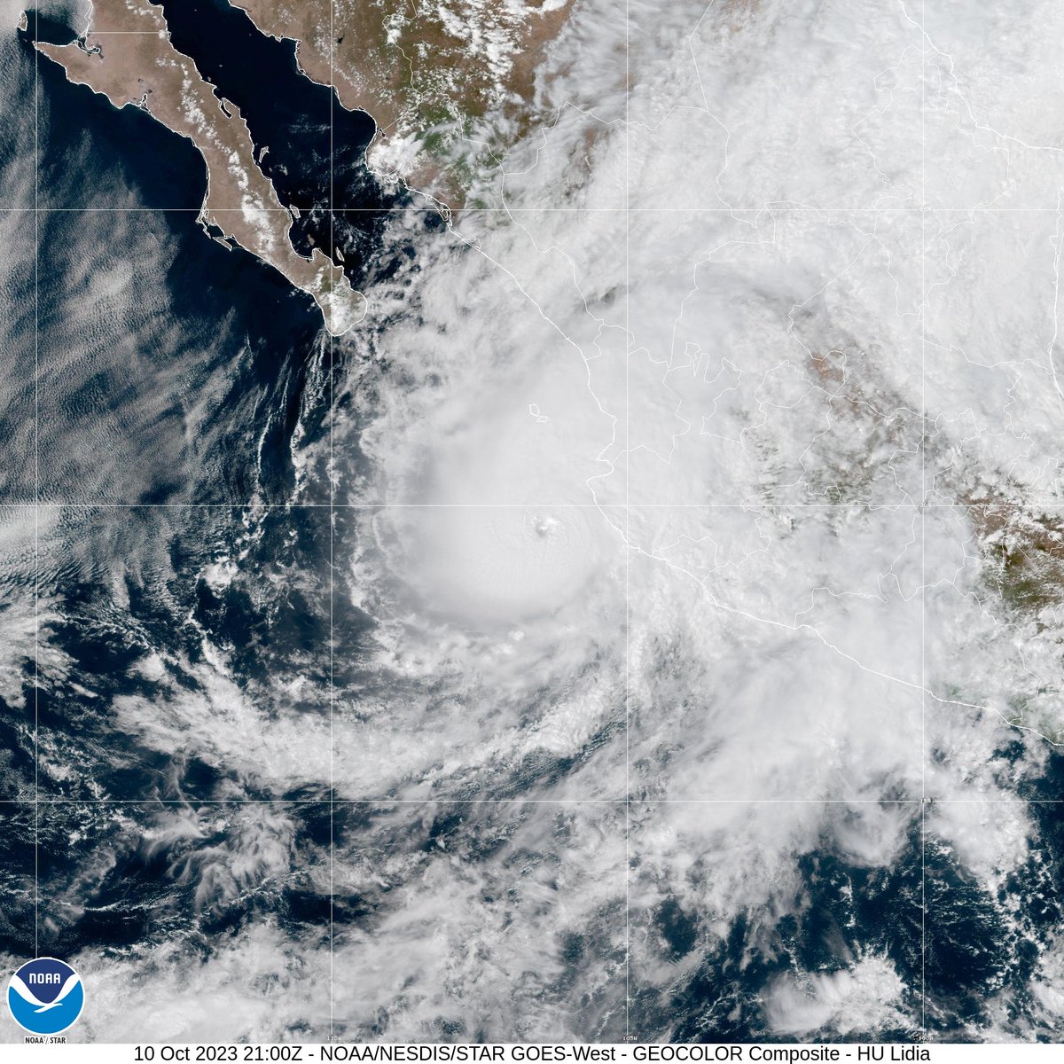
Update: 3:30 PM MDT Tuesday Oct 10 - #Lidia rapidly strengthens into an extremely dangerous category 4 hurricane with maximum winds near 140 mph (220 km/h). Some additional strengthening is possible before Lidia makes landfall this evening. hurricanes.gov
United States Trends
- 1. Bama 30,2 B posts
- 2. Miami 103 B posts
- 3. Clemson 15,6 B posts
- 4. South Carolina 24,3 B posts
- 5. #WWENXT 10,8 B posts
- 6. XDefiant 9.301 posts
- 7. Cam Payne N/A
- 8. Warde Manuel 2.071 posts
- 9. Ubisoft 8.047 posts
- 10. #CFBPlayoff 4.586 posts
- 11. Africa 268 B posts
- 12. Gundam 108 B posts
- 13. Eric Dixon N/A
- 14. #MAFS N/A
- 15. Аirdrop 1,07 Mn posts
- 16. #Uniswap 814 B posts
- 17. Villanova 1.602 posts
- 18. Lindsey 27,9 B posts
- 19. Hegseth 136 B posts
- 20. Committee 183 B posts
Something went wrong.
Something went wrong.


